Portal:Myanmar
Portal maintenance status: (March 2022)
|

Myanmar, officially the Republic of the Union of Myanmar and also rendered Burma (the official English form until 1989), is a country in northwest Southeast Asia. It is the largest country by area in Mainland Southeast Asia and has a population of about 55 million. It is bordered by India to its west, Bangladesh to its southwest, China to its northeast, Laos and Thailand to its east and southeast, and the Andaman Sea and the Bay of Bengal to its south and southwest. The country's capital city is Naypyidaw, and its largest city is Yangon (formerly Rangoon).
Myanmar is a member of the East Asia Summit, Non-Aligned Movement, ASEAN, and BIMSTEC, but it is not a member of the Commonwealth of Nations despite once being part of the British Empire. Myanmar is a Dialogue Partner of the Shanghai Cooperation Organization. The country is very rich in natural resources, such as jade, gems, oil, natural gas, teak and other minerals, as well as also endowed with renewable energy, having the highest solar power potential compared to other countries of the Great Mekong Subregion. However, Myanmar has long suffered from instability, factional violence, corruption, poor infrastructure, as well as a long history of colonial exploitation with little regard to human development. In 2013, its GDP (nominal) stood at US$56.7 billion and its GDP (PPP) at US$221.5 billion. The income gap in Myanmar is among the widest in the world, as a large proportion of the economy is controlled by cronies of the military junta. Myanmar is one of the least developed countries; as of 2020, according to the Human Development Index, it ranks 147 out of 189 countries in terms of human development, the lowest in Southeast Asia. Since 2021, more than 600,000 people were displaced across Myanmar due to the surge in violence post-coup, with more than 3 million people in dire need of humanitarian assistance. (Full article...)
Selected articles - load new batch
-
Image 1
The Burmese–Siamese War (1547–1549) (Burmese: ယိုးဒယား-မြန်မာစစ် (၁၅၄၇–၄၉); Thai: สงครามพม่า-สยาม พ.ศ. 2090–2092), also known as the Shwehti war (Thai: สงครามพระเจ้าตะเบ็งชเวตี้) was the first war fought between the Toungoo dynasty of Burma and the Ayutthaya Kingdom of Siam, and the first of the Burmese–Siamese wars that would continue until the middle of the 19th century. The war is notable for the introduction of early modern warfare to the region. It is also notable in Thai history for the death in battle of Siamese Queen Suriyothai on her war elephant; the conflict is often referred to in Thailand as the War that Led to the Loss of Queen Suriyothai (สงครามคราวเสียสมเด็จพระสุริโยไท).
The casus belli have been stated as a Burmese attempt to expand their territory eastwards after a political crisis in Ayutthaya as well as an attempt to stop Siamese incursions into the upper Tenasserim coast. The war, according to the Burmese, began in January 1547 when Siamese forces conquered the frontier town of Tavoy (Dawei). Later in the year, the Burmese forces led by Gen. Saw Lagun Ein retook the Upper Tenasserim coast down to Tavoy. Next year, in October 1548, three Burmese armies led by King Tabinshwehti and his deputy Bayinnaung invaded Siam through the Three Pagodas Pass. The Burmese forces penetrated up to the capital city of Ayutthaya but could not take the heavily fortified city. One month into the siege, Siamese counterattacks broke the siege, and drove back the invasion force. But the Burmese negotiated a safe retreat in exchange for the return of two important Siamese nobles (the heir apparent Prince Ramesuan, and Thammaracha of Phitsanulok) whom they had captured. (Full article...) -
Image 2

Rice plantation in Myanmar, 2006
Rice production in Myanmar accounts for approximately 43% of total agricultural production in the country, making it the seventh largest producer of rice in the world. Out of 67.6 million hectares of land, 12.8 million are used for cultivation. In 2019 alone, Myanmar accounted for 13,300 million metric tons of milled rice production.
Throughout history, Myanmar established itself as a major rice producing and exporting country due to favourable weather for rice paddies and governmental intervention in the form of agricultural policies. The production is undertaken using traditional cultivation methods, particularly during monsoon season, which has led to the development of different varieties of rice. Recent global economic policies have led to increasing international cooperation with NGOs and other organisations, that have provided financial and technological assistance to rice farmers. (Full article...) -
Image 3
Maung Thura "Zarganar" (also called Zaganar, Burmese: ဇာဂနာ; also Zargana, pronounced [zàɡənà]); born 27 January 1961) is a popular Burmese comedian, film actor, and a film director as well as a fierce critic and often political prisoner of the Burmese military government. Known for his wicked puns against the government which is a military junta, Zarganar, whose name translates to "tweezers", is widely considered to be the most popular comedian and satirist in Myanmar.
In September 2006, Zarganar was banned indefinitely from performing publicly or participating in any kind of entertainment related work. He was arrested on 4 June 2008 for speaking to foreign media about the situation of millions of people left homeless after a cyclone devastated the Irrawaddy Delta. In November 2008, he was sentenced to 59 years in prison, convicted of "public order offenses", under four sections of the criminal code—17/2, 32 (b), 295 (a) and 505 (b), much more than the anticipated maximum of two years. On 16 February 2009, following the appeals by the family, Yangon Divisional Court reduced the prison sentence by "up to 24 years", bringing the sentence down to 35 years. In December 2008, Zarganar has been sent to Myitkyina Prison in Kachin State in the country's far north, from which he was freed on 11 October 2011 in a mass amnesty of political prisoners. (Full article...) -
Image 4
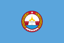
Mandalay Region (Burmese: မန္တလေးတိုင်းဒေသကြီး, pronounced [máɰ̃dəlé táiɰ̃ dèθa̰ dʑí]; formerly Mandalay Division) is an administrative division of Myanmar. It is located in the center of the country, bordering Sagaing Region and Magway Region to the west, Shan State to the east, and Bago Region and Kayin State to the south. The regional capital is Mandalay. To the south of the region lies the national capital of Naypyidaw. The division consists of eleven districts, which are subdivided into 28 townships and 2,320 wards and village-tracts.
Mandalay Region is important in Myanmar's economy, accounting for 15% of the national economy. It is under the administration of the Mandalay Region Government. (Full article...) -
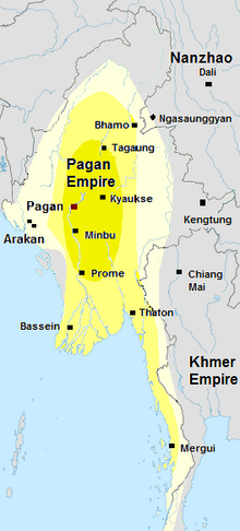
Image 5Pagan empire, c. 1210.
Pagan empire during Sithu II's reign. Kengtung and Chiang Mai are also claimed to be part of the empire according to the Burmese chronicles. Pagan incorporated key ports of lower Burma into its core administration by the 13th century.
The Kingdom of Pagan (Burmese: ပုဂံခေတ်, pronounced [bəɡàɰ̃ kʰɪʔ], lit. 'Pagan Period'; also known as the Pagan dynasty and the Pagan Empire; also the Bagan dynasty or Bagan Empire) was the first Burmese kingdom to unify the regions that would later constitute modern-day Myanmar. Pagan's 250-year rule over the Irrawaddy valley and its periphery laid the foundation for the ascent of Burmese language and culture, the spread of Bamar ethnicity in Upper Myanmar, and the growth of Theravada Buddhism in Myanmar and in mainland Southeast Asia.
The kingdom grew out of a small 9th-century settlement at Pagan (present-day Bagan) by the Mranma/Burmans. Over the next two hundred years, the small principality gradually grew to absorb its surrounding regions until the 1050s and 1060s when King Anawrahta founded the Pagan Empire, presumably for the first time unifying under one polity the Irrawaddy valley and its periphery. By the late 12th century, Anawrahta's successors had extended their influence farther to the south into the upper Malay Peninsula, to the east at least to the Salween river, in the farther north to below the current China border, and to the west, in northern Arakan and the Chin Hills. In the 12th and 13th centuries, Pagan, alongside the Khmer Empire, was one of two main empires in mainland Southeast Asia. (Full article...) -
Image 6
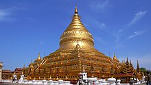
The Shwezigon Pagoda or Shwezigon Paya (ရွှေစည်းခုံဘုရား [ɕwèzíɡòʊɰ̃ pʰəjá]) is a Buddhist stupa located in Nyaung-U, Myanmar. A prototype of Burmese stupas, it consists of a circular gold leaf-gilded stupa surrounded by smaller temples and shrines. Construction of the Shwezigon Pagoda began during the reign of King Anawrahta (r. 1044–1077), the founder of the Pagan Empire, in 1059–1060 and was completed in 1102, during the reign of his son King Kyansittha. Over the centuries the pagoda had been damaged by many earthquakes and other natural calamities, and has been refurbished several times. In recent renovations it has been covered by more than 30,000 copper plates. However, the lowest level terraces have remained as they were.
This pagoda, a sacred Buddhist religious place, is believed to enshrine a bone and tooth of Gautama Buddha. The pagoda is in the form of a cone formed by five square terraces with a central solid core. There are footprints below the four standing Buddha statues here. Jataka legends are depicted on glazed terra-cotta tiles set into three rectangular terraces. At the entrance of the pagoda there are large statues of guardians of the temple. There are also four bronze standing statues of Buddha which are stated to be of the current age Buddha. At the outer limits of the pagoda there are 37 nats deified along with an intricately carved wooden sculpture of Thagyamin, the Burmese version of the Indian god Indra. Within the compound of the Shwezigon Pagoda there is a stone pillar containing Mon language inscriptions dedicated by Kyansittha. (Full article...) -
Image 7Nga Tet Pya (Burmese: ငတက်ပြား, [ŋə tɛʔ pjá], also [ŋə dɛʔ bjá]; also spelled Ngatetpya or Nga Tat Pya) was a 14th-century Burmese outlaw who later became a commander in the royal army during the reign of King Thado Minbya of Ava. A well-known folkloric figure in Burmese culture, he is remembered as a Robin Hood-like character, who robbed the rich, and shared his loot with the poor. He is also known as the husband of Chantha, who is venerated by believers as the Amay Gyan nat spirit. (Full article...)
-
Image 8
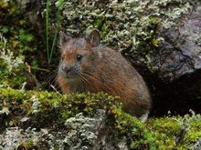
Forrest's pika (Ochotona forresti) is a species of mammal in the pika family, Ochotonidae. It is found in Bhutan, China, India, and Myanmar. The summer dorsal pelage and ventral pelage are dark rufous or blackish brown, and the winter dorsal pelage is a grayish brown, slightly lighter in tone than the ventral pelage. It is a generalist herbivore. It was assessed by the IUCN Red List of Endangered Species as insufficiently known in 1994, as near threatened in 1996, and re-assessed in 2008 as a species of least concern. (Full article...) -
Image 9

Thura Ma Chit Po (Burmese: သူရ မချစ်ပို; February 1908 – 8 April 1949) was a Burmese woman who was the one and only civilian woman to have received the Thura medal for bravery. She gathered intelligence on the Karen National Defence Organisation (KNDO) on behalf of the Myanmar Military before she was caught and executed by the KNDO insurgents. (Full article...) -
Image 10

Inle Lake (Burmese: အင်းလေးကန်; MLCTS: ang: le: kan, [ʔɪ́ɰ̃lé kàɰ̃]), a freshwater lake located in the Nyaungshwe Township of Shan State, part of Shan Hills in Myanmar (Burma). It is the second largest lake in Myanmar, with an estimated surface area of 44.9 square miles (116 km2), and one of the highest at an elevation of 2,900 feet (880 m). During the dry season, the average water depth is 7 feet (2.1 m), with the deepest point being 12 feet (3.7 m). During the rainy season, this can increase by 5 feet (1.5 m).
The watershed area for the lake lies to a large extent to the north and west of the lake. The lake drains through the Nam Pilu or Balu Chaung on its southern end. There is also a hot spring on its northwestern shore. (Full article...)
Did you know (auto-generated) - load new batch

- ... that Maw Htun Aung, a Shan Nationalities League for Democracy candidate in the 2020 Myanmar general election, is Kachin, not Shan?
- ... that the Myanmar Photo Archive (example photograph shown) revealed "a side of modern Myanmar that, until very recently, remained hidden in dusty attics"?
- ... that Rangoon kept its own time for more than two decades after Burma Standard Time first came into effect?
- ... that former Burmese actress Honey Nway Oo turned rebel and took up arms against the military junta following the 2021 Myanmar coup d'état?
- ... that Rolling Stone named Mission of Burma's "Academy Fight Song" as one of the 100 greatest debut singles of all time?
- ... that Maung O, Prince of Salin, and his sister Nanmadaw Me Nu became de facto rulers of Burma when King Bagyidaw was suffering from depression?
- ... that Molly Burman resumed releasing music three years later after finding that "Happy Things" had accrued a million streams on Spotify?
- ... that squatters in Myanmar were punished for protesting against the 2021 coup d'état by being evicted?
Related portals and projects
General images - load new batch
-
Image 1Two female musicians play the saung at a performance in Mandalay. (from Culture of Myanmar)
-
Image 219th-century funeral cart and spire, which would form part of the procession from the home to the place of cremation (from Culture of Myanmar)
-
Image 3British soldiers dismantling cannons belonging to King Thibaw's forces, Third Anglo-Burmese War, Ava, 27 November 1885. Photographer: Hooper, Willoughby Wallace (1837–1912). (from History of Myanmar)
-
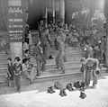
Image 4British soldiers remove their shoes at the entrance of Shwedagon Pagoda. To the left, a sign reads "Foot wearing is strictly prohibited" in Burmese, English, Tamil, and Urdu. (from Culture of Myanmar)
-
Image 5A bull fight, 19th-century watercolour (from Culture of Myanmar)
-
Image 6Hlei pyaingbwè - a Burmese regatta (from Culture of Myanmar)
-
Image 8Grandfather Island, Dawei (from Geography of Myanmar)
-
Image 9Sculpture of Myanmar mythical lion (from Culture of Myanmar)
-
Image 10Saint Mary's Cathedral in Downtown Yangon is the largest Roman Catholic cathedral in Burma. (from Culture of Myanmar)
-
Image 11Salween river at Mae Sam Laep on the Thai-Myanmar border (from Geography of Myanmar)
-
Image 12A wedding procession, with the groom and bride dressed in traditional Burmese wedding clothes, reminiscent of royal attire (from Culture of Myanmar)
-
Image 13Vegetable stall on the roadside at the Madras Lancer Lines, Mandalay, January 1886. Photographer: Hooper, Willoughby Wallace (1837–1912). (from History of Myanmar)
-
Image 14A group of Buddhist worshipers at Shwedagon Pagoda, an important religious site for Burmese Buddhists (from Culture of Myanmar)
-
Image 17Pagan Kingdom during Narapatisithu's reign. Burmese chronicles also claim Kengtung and Chiang Mai. Core areas shown in darker yellow. Peripheral areas in light yellow. Pagan incorporated key ports of Lower Burma into its core administration by the 13th century. (from History of Myanmar)
-
Image 18Myanmar (Burma) map of Köppen climate classification (from Geography of Myanmar)
-
Image 19The paddle steamer Ramapoora (right) of the British India Steam Navigation Company on the Rangoon river having just arrived from Moulmein. 1895. Photographers: Watts and Skeen (from History of Myanmar)
-
Image 21Aung San Suu Kyi addresses crowds at the NLD headquarters shortly after her release. (from History of Myanmar)
-
Image 22Protesters in Yangon with a banner that reads non-violence: national movement in Burmese, in the background is Shwedagon Pagoda. (from History of Myanmar)
-
Image 23Recorder's Court on Sule Pagoda Road, with the Sule Pagoda at the far end, Rangoon, 1868. Photographer: J. Jackson. (from History of Myanmar)
-
Image 24Aerial view of a burned Rohingya village in Rakhine state, September 2017 (from History of Myanmar)
-
Image 25The shores of Irrawaddy River at Nyaung-U, Bagan (from Geography of Myanmar)
-
Image 26Political Map of Burma (Myanmar) c. 1450 CE. (from History of Myanmar)
-
Image 27The restored Taungoo or Nyaungyan dynasty c. 1650 CE. (from History of Myanmar)
-
Image 29Portuguese ruler and soldiers mounting an Elephant. Philips, Jan Caspar (draughtsman and engraver) (from History of Myanmar)
-
Image 30Temples at Mrauk U, was the capital of the Mrauk U Kingdom, which ruled over what is now Rakhine State. (from History of Myanmar)
-
Image 31Boxing match, 19th-century watercolour (from Culture of Myanmar)
-
Image 32Former US President Barack Obama poses barefoot on the grounds of Shwedagon Pagoda, one of Myanmar's major Buddhist pilgrimage sites. (from Culture of Myanmar)
-
Image 33A large fracture on the Mingun Pahtodawgyi caused by the 1839 Ava earthquake. (from Geography of Myanmar)
-
Image 34A theatrical performance of the Mon dance (from Culture of Myanmar)
-
Image 37British soldiers on patrol in the ruins of the Burmese town of Bahe during the advance on Mandalay, January 1945. (from History of Myanmar)
-
Image 38Protesters in Yangon carrying signs reading "Free Daw Aung San Suu Kyi" on 8 February 2021. (from History of Myanmar)
-
Image 40Myinhkin thabin - equestrian sport (from Culture of Myanmar)
Major topics
Categories
More topics
|
| |||||||||||||||||||||||||||||||||||||||||||||||||||||||||||||||||||||||||||||||||||||||||||||||||||||||||||||||||||||||||||||||||||||||||||||||||||||||||||||||||||||||||||||||||||||||||||||||||||||||||||
Associated Wikimedia
The following Wikimedia Foundation sister projects provide more on this subject:
-
Commons
Free media repository -
Wikibooks
Free textbooks and manuals -
Wikidata
Free knowledge base -
Wikinews
Free-content news -
Wikiquote
Collection of quotations -
Wikisource
Free-content library -
Wikiversity
Free learning tools -
Wikivoyage
Free travel guide -
Wiktionary
Dictionary and thesaurus


