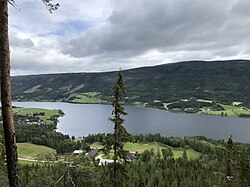
Otnes
Otnes | |
|---|---|
Village | |
 View of the village | |
| Coordinates: 61°45′35″N 11°10′19″E / 61.75968°N 11.1719°E | |
| Country | Norway |
| Region | Eastern Norway |
| County | Innlandet |
| District | Østerdalen |
| Municipality | Rendalen Municipality |
| Area | |
• Total | 0.49 km2 (0.19 sq mi) |
| Elevation | 277 m (909 ft) |
| Population (2021)[1] | |
• Total | 263 |
| • Density | 541/km2 (1,400/sq mi) |
| Time zone | UTC+01:00 (CET) |
| • Summer (DST) | UTC+02:00 (CEST) |
| Post Code | 2485 Rendalen |
Otnes is a village in Rendalen Municipality in Innlandet county, Norway. The village is located along the lake Lomnessjøen, about 4.5 kilometres (2.8 mi) north of the village of Åkre. The municipal centre of Bergset lies about 15 kilometres (9.3 mi) to the north of Otnes.
The 0.49-square-kilometre (120-acre) village has a population (2021) of 263 and a population density of 541 inhabitants per square kilometre (1,400/sq mi).[1]
Otnes was the administrative centre of the old municipality of Ytre Rendal which existed from 1880 until 1965 when it was merged into Rendalen. Otnes has one church in the village, Ytre Rendal Church. The tiny village contains a Gas station, Grocery store, small Bank inside the grocery store, Library and a Doctor's office.
References
[edit]- ^ a b c Statistisk sentralbyrå (1 January 2021). "Urban settlements. Population and area, by municipality".
- ^ "Otnes, Rendalen". yr.no. Retrieved 18 February 2022.


