Bergset
Bergset | |
|---|---|
Village | |
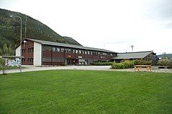
 View of the village community centre | |
| Coordinates: 61°53′29″N 11°04′40″E / 61.89126°N 11.07769°E | |
| Country | Norway |
| Region | Eastern Norway |
| County | Innlandet |
| District | Østerdalen |
| Municipality | Rendalen Municipality |
| Elevation | 321 m (1,053 ft) |
| Time zone | UTC+01:00 (CET) |
| • Summer (DST) | UTC+02:00 (CEST) |
| Post Code | 2484 Rendalen |
Bergset is the administrative centre of Rendalen Municipality in Innlandet county, Norway. The village is located on the western shore of the river Renaelva, about 15 kilometres (9.3 mi) north of the village of Otnes in the largely rural Østerdalen valley. The 1-square-kilometre (250-acre) village has a population (2012) of 243 and a population density of 245 inhabitants per square kilometre (630/sq mi).[2][3]

Bergset was also the administrative centre of the former municipality of Øvre Rendal which is now a part of Rendalen. Øvre Rendal Church, built in 1761, is located in Bergset. The Rendalen Village Museum in Bergset contains a collection relating to the author Jacob Breda Bull (1853–1930), who was a resident of Rendalen. Bull was buried in the nearby Ytre Rendal Church.[4]
References
[edit]- ^ "Bergset, Rendalen". yr.no. Retrieved 18 February 2022.
- ^ Statistisk sentralbyrå (1 January 2012). "Urban settlements. Population and area, by municipality".
- ^ Olsen Haugen, Morten, ed. (25 January 2022). "Bergset". Store norske leksikon (in Norwegian). Kunnskapsforlaget. Retrieved 18 February 2022.
- ^ "Rendalen Bygdemuseum". museainordosterdalen. Retrieved 1 September 2018.
External links
[edit]


