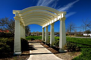
Northwood, New Zealand
Northwood | |
|---|---|
 Northwood Estate | |
 | |
| Coordinates: 43°27′29″S 172°36′58″E / 43.458°S 172.616°E | |
| Country | New Zealand |
| City | Christchurch |
| Local authority | Christchurch City Council |
| Electoral ward | Harewood |
| Community board | Waimāero Fendalton-Waimairi-Harewood |
| Area | |
| • Land | 723 ha (1,787 acres) |
| Population (June 2024)[1] | |
• Total | 4,560 |
| McLeans Island | Belfast | |
|
|
Bottle Lake | |
| Harewood | Casebrook | Redwood |
Northwood is a suburb on the northern outskirts of Christchurch city. It was developed in 2000 as a subdivision of Belfast on land previously used for apple orchards.[2][3] The name "Northwood" was accepted at a meeting of the Shirley-Papanui Community Board on 2 February 2000.[4][5]
Farmland north-west of what later became Northwood was developed into Peppers Clearwater Resort in 1998.[6]
The Groynes is a large park between Northwood and Clearwater.[7] Styx Mill Conservation Reserve is on the south side of Northwood.[8]
Demographics
[edit]Northwood, comprising the statistical areas of Northwood and Clearwater, covers 7.23 km2 (2.79 sq mi).[9] It had an estimated population of 4,560 as of June 2024, with a population density of 631 people per km2.
| Year | Pop. | ±% p.a. |
|---|---|---|
| 2006 | 2,973 | — |
| 2013 | 4,158 | +4.91% |
| 2018 | 4,266 | +0.51% |
| Source: [10] | ||

Northwood had a population of 4,266 at the 2018 New Zealand census, an increase of 108 people (2.6%) since the 2013 census, and an increase of 1,293 people (43.5%) since the 2006 census. There were 1,650 households, comprising 2,097 males and 2,166 females, giving a sex ratio of 0.97 males per female, with 681 people (16.0%) aged under 15 years, 609 (14.3%) aged 15 to 29, 2,037 (47.7%) aged 30 to 64, and 939 (22.0%) aged 65 or older.
Ethnicities were 83.5% European/Pākehā, 4.6% Māori, 0.8% Pasifika, 13.7% Asian, and 2.5% other ethnicities. People may identify with more than one ethnicity.
The percentage of people born overseas was 24.0, compared with 27.1% nationally.
Although some people chose not to answer the census's question about religious affiliation, 41.6% had no religion, 48.3% were Christian, 0.1% had Māori religious beliefs, 0.8% were Hindu, 1.3% were Muslim, 0.8% were Buddhist and 1.1% had other religions.
Of those at least 15 years old, 882 (24.6%) people had a bachelor's or higher degree, and 546 (15.2%) people had no formal qualifications. 1,002 people (27.9%) earned over $70,000 compared to 17.2% nationally. The employment status of those at least 15 was that 1,701 (47.4%) people were employed full-time, 561 (15.6%) were part-time, and 93 (2.6%) were unemployed.[10]
| Name | Area (km2) |
Population | Density (per km2) |
Households | Median age | Median income |
|---|---|---|---|---|---|---|
| Clearwater | 5.71 | 699 | 122 | 279 | 50.8 years | $50,300[11] |
| Northwood | 1.45 | 3,567 | 2,460 | 1,371 | 48.2 years | $37,400[12] |
| New Zealand | 37.4 years | $31,800 |
Northwood Supa Centre
[edit]The Northwood Supa Centre shopping complex opened in the 2000s.[13] It covers an area of 33,062 m2 and features 29 retailers, including Burnsco, PandaMart, Spotlight, Repco and Smiths City.[14]
References
[edit]- ^ "Aotearoa Data Explorer". Statistics New Zealand. Retrieved 26 October 2024.
- ^ "Community profile - November 2014 - Belfast" (PDF). Christchurch City Council. November 2014.
- ^ Steeman, Marta (7 January 2014). "Apple Fields founder Kain dies". The Press.
- ^ "Proposed New Right of Way and Road Names" (PDF). Christchurch City Council. 2 February 2000.
- ^ "Christchurch Street Names: N - O: Northwood Boulevard" (PDF). Christchurch City Libraries. Retrieved 5 September 2021.
- ^ "History". Clearwater Golf Club. 2016.
- ^ "The Groynes". Christchurch City Council. Retrieved 5 September 2021.
- ^ "Styx Mill Conservation Reserve". Christchurch City Council. Retrieved 5 September 2021.
- ^ "ArcGIS Web Application". statsnz.maps.arcgis.com. Retrieved 28 January 2024.
- ^ a b "Statistical area 1 dataset for 2018 Census". Statistics New Zealand. March 2020. Clearwater (316800) and Northwood (317400).
- ^ 2018 Census place summary: Clearwater
- ^ 2018 Census place summary: Northwood
- ^ "2017 Commercial Centre Factsheet - Belfast / Northwood" (PDF). ccc.govt.nz. Christchurch City Council.
- ^ Steeman, Marta (4 March 2019). "Northwood Supa Centre fetches $81.7 million in one of Christchurch's largest property deals". stuff.co.nz.
