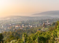
Municipality of Semič
Appearance
Municipality of Semič
Občina Semič | |
|---|---|
 | |
 Location of the Municipality of Semič in Slovenia | |
| Coordinates: 45°39′16″N 15°10′42″E / 45.6544°N 15.1783°E | |
| Country | |
| Government | |
| • Mayor | Polona Kambič |
| Area | |
| • Total | 146.7 km2 (56.6 sq mi) |
| Population (2002)[1] | |
| • Total | 3,710 |
| • Density | 25/km2 (66/sq mi) |
| Time zone | UTC+01 (CET) |
| • Summer (DST) | UTC+02 (CEST) |
| Website | www |
The Municipality of Semič (pronounced [ˈseːmitʃ]; Slovene: Občina Semič) is a municipality in Slovenia in the traditional region of White Carniola in southeastern Slovenia. The municipality is included in the Southeast Slovenia Statistical Region. Its seat is the settlement of Semič.
Settlements
[edit]
In addition to the municipal seat of Semič, the municipality also includes the following settlements:
- Blatnik pri Črmošnjicah
- Brezje pri Rožnem Dolu
- Brezje pri Vinjem Vrhu
- Brezova Reber
- Brezovica pri Črmošnjicah
- Brstovec
- Cerovec pri Črešnjevcu
- Črešnjevec pri Semiču
- Črmošnjice
- Gaber pri Črmošnjicah
- Gornje Laze
- Gradnik
- Hrib pri Cerovcu
- Hrib pri Rožnem Dolu
- Kal
- Komarna Vas
- Krupa
- Krvavčji Vrh
- Lipovec
- Maline pri Štrekljevcu
- Mašelj
- Moverna Vas
- Nestoplja Vas
- Omota
- Oskoršnica
- Osojnik
- Planina
- Podreber
- Potoki
- Praproče
- Praprot
- Preloge
- Pribišje
- Pugled
- Rožni Dol
- Sela pri Vrčicah
- Sodji Vrh
- Sovinek
- Sredgora
- Srednja Vas
- Starihov Vrh
- Stranska Vas pri Semiču
- Štrekljevec
- Trebnji Vrh
- Vinji Vrh pri Semiču
- Vrčice
References
[edit]External links
[edit] Media related to Municipality of Semič at Wikimedia Commons
- Municipality of Semič on Geopedia
- Municipality of Semič website


