Municipality of Šmarje pri Jelšah
Appearance
Municipality of Šmarje pri Jelšah
Občina Šmarje pri Jelšah | |
|---|---|
 | |
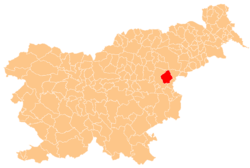
 Location of the Municipality of Šmarje pri Jelšah in Slovenia | |
| Coordinates: 46°19′N 15°40′E / 46.317°N 15.667°E | |
| Country | |
| Government | |
| • Mayor | Matija Čakš |
| Area | |
• Total | 107.7 km2 (41.6 sq mi) |
| Population (2016)[1] | |
• Total | 10,259 |
| • Density | 95/km2 (250/sq mi) |
| Time zone | UTC+01 (CET) |
| • Summer (DST) | UTC+02 (CEST) |
| Website | smarje |
The Municipality of Šmarje pri Jelšah (pronounced [ˈʃmaːɾjɛ pɾi ˈjeːlʃax]; Slovene: Občina Šmarje pri Jelšah) is a municipality in the traditional region of Styria in northeastern Slovenia. The seat of the municipality is the town of Šmarje pri Jelšah. Šmarje pri Jelšah became a municipality in 1994.[2]
Settlements
[edit]
In addition to the municipal seat of Šmarje pri Jelšah, the municipality also includes the following settlements:
- Babna Brda
- Babna Gora
- Babna Reka
- Beli Potok pri Lembergu
- Belo
- Bezgovica
- Bobovo pri Šmarju
- Bodrež
- Bodrišna Vas
- Brecljevo
- Brezje pri Lekmarju
- Bukovje v Babni Gori
- Cerovec pri Šmarju
- Dol pri Pristavi
- Dol pri Šmarju
- Dragomilo
- Dvor
- Gaj
- Globoko pri Šmarju
- Gornja Vas
- Grliče
- Grobelce
- Grobelno (Šmarje portion)*
- Hajnsko
- Jazbina
- Jerovska Vas
- Ješovec pri Šmarju
- Kamenik
- Konuško
- Koretno
- Korpule
- Kristan Vrh
- Krtince
- Laše
- Lekmarje
- Lemberg pri Šmarju
- Lipovec
- Mala Pristava
- Mestinje
- Močle
- Nova Vas pri Šmarju
- Orehovec
- Pečica
- Pijovci
- Platinovec
- Polžanska Gorca
- Polžanska Vas
- Predel
- Predenca
- Preloge pri Šmarju
- Pustike
- Rakovec
- Senovica
- Šentvid pri Grobelnem
- Šerovo
- Škofija
- Sladka Gora
- Sotensko pri Šmarju
- Spodnja Ponkvica
- Spodnje Mestinje
- Spodnje Selce
- Spodnje Tinsko
- Stranje
- Strtenica
- Sveti Štefan
- Topolovec
- Vinski Vrh pri Šmarju
- Vodenovo
- Vrh
- Vršna Vas
- Zadrže
- Zastranje
- Završe pri Grobelnem
- Zgornje Tinsko
- Zibika
- Zibiška Vas
*Because the settlement of Grobelno straddles two municipalities, it appears on this list as well as the Municipality of Šentjur list
References
[edit]- ^ a b "Občina Šmarje pri Jelšah". Statistični urad Republike Slovenije. Retrieved April 9, 2020.
- ^ Vzpostavitev lokalne samouprave v Republiki Sloveniji v številkah. Ljubljana: Statistični urad Republike Slovenije. 2007. p. 133. Retrieved February 11, 2020.
External links
[edit] Media related to Municipality of Šmarje pri Jelšah at Wikimedia Commons
- Municipality of Šmarje pri Jelšah on Geopedia
- Municipality of Šmarje pri Jelšah website


