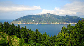
Minami Sanriku Kinkasan Quasi-National Park
Appearance
| Minami Sanriku Kinkasan Quasi-National Park | |
|---|---|
| 南三陸金華山国定公園 | |
 | |
 | |
| Location | Miyagi Prefecture, Japan |
| Coordinates | 38°32′3″N 141°30′58″E / 38.53417°N 141.51611°E |
| Area | 139.02 km2 |
| Established | 30 March 1979 |
Minami Sanriku Kinkasan Quasi-National Park (南三陸金華山国定公園, Minami Sanriku Kinkasan Kokutei Kōen) was a Quasi-National Park on the Pacific coast of northern Miyagi Prefecture, Japan. Established in 1979, the park extended along 180 km of the coast of southern Sanriku and encompassed Mount Kinka.[1][2][3] On 31 March 2015, in the aftermath of the 2011 Tōhoku earthquake and tsunami, the Park was incorporated into Sanriku Fukkō National Park.[4]
Related municipalities
[edit]See also
[edit]References
[edit]- ^ "栗駒/南三陸金華山/蔵王/男鹿". National Parks Association of Japan. Retrieved 5 February 2012.[permanent dead link]
- ^ "List of Quasi-National Parks" (PDF). Ministry of the Environment. Retrieved 5 February 2012.
- ^ "Minami Sanriku Kinkasan Quasi-National Park". Miyagi Prefecture. Archived from the original on 9 September 2012. Retrieved 5 February 2012.
- ^ 三陸復興国立公園の公園区域の変更(南三陸金華山国定公園区域の編入)について [About the Change in Area of Sanriku Fukkō National Park] (Transfer of the Area of Minami Sanriku Kinkasan Quasi-National Park)] (in Japanese). Ministry of the Environment. 27 March 2015. Retrieved 13 August 2019.
- ^ "Designation of the Natural Parks of Miyagi Prefecture". Miyagi Prefecture. Archived from the original on 23 March 2011. Retrieved 5 February 2012.
External links
[edit]Wikimedia Commons has media related to Minamisanriku-Kinkazan Quasi-National Park.
- (in Japanese) Map of the Natural Parks of Miyagi Prefecture
- (in Japanese) Detailed maps of the Natural Parks of Miyagi Prefecture
