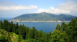
Kinkasan
Appearance
Native name: Japanese: 金華山 | |
|---|---|
 View from Oshika Peninsula | |
 | |
| Geography | |
| Location | Pacific Ocean |
| Coordinates | 38°17′43″N 141°34′00″E / 38.29528°N 141.56667°E |
| Archipelago | Oshika |
| Area | 10.28 km2 (3.97 sq mi) |
| Coastline | 25 km (15.5 mi) |
| Highest elevation | 445 m (1460 ft) |
| Highest point | Kinkasan |
| Administration | |
Japan | |
| Prefecture | Miyagi |
| City | Ishinomaki |
| Demographics | |
| Population | 6 (2004) |
| Ethnic groups | Japanese |

Kinkasan (金華山, Kinkasan, or Kinkazan), is a small island in Miyagi Prefecture in north-eastern Japan. It lies in the Pacific Ocean approximately one kilometer off the Oshika Peninsula.[1]
Geography
[edit]Kinkasan is 9.5 km2 (3.7 sq mi) in area, and its highest point is the pyramid-shaped Mount Kinka, which stands at 445 m (1,460 ft).[1]
It can be reached by ferry from Ishinomaki.[2]
History
[edit]There is a shrine on the island, called Koganeyama-jinja, which dates from the 8th century.[3]
References
[edit]- ^ a b "Mt. Kinka (Kinkasan Island)". Matsushima. Japan-i. Archived from the original on May 4, 2010. Retrieved 15 March 2011.
- ^ Chris Rowthorn (15 September 2010). "Northern Honshu". Japan. Lonely Planet. p. 530. ISBN 9781742203539. Retrieved 13 February 2014.
- ^ "Kinkasan". Japan: the official guide. Japan National Tourism Organization. Retrieved 13 December 2012.
External links
[edit]![]() Media related to Kinkasan (Miyagi) at Wikimedia Commons
Media related to Kinkasan (Miyagi) at Wikimedia Commons
Wikivoyage has a travel guide for Kinkasan.
