Mborokua
Appearance
This article needs additional citations for verification. (August 2023) |
Nickname: Mary Island | |
|---|---|
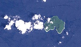
 Landsat image of Mborokua Island, Solomon islands | |
 | |
| Geography | |
| Coordinates | 9°01′S 158°44′E / 9.02°S 158.74°E |
| Area | 4 km2 (1.5 sq mi) |
| Administration | |
| Province | |
| Demographics | |
| Population | 0 |
Mborokua (also known as Mary Island) is an uninhabited, jungle-covered volcanic island in Western Province, Solomon Islands, 30 km west of the Russell Islands. It is occasionally visited by local fishermen, as well as by dive tours.[1]
See also
[edit]References
[edit]- ^ Vedder, John Graham (1986). Geology and Offshore Resources of Pacific Island Arcs--central and Western Solomon Islands. Circum-Pacific Council for Energy and Mineral Resources. p. 306. ISBN 9780933687035.
External links
[edit]- Satellite view of Mborokua from Google Maps
