Mansfield Hollow State Park
| Mansfield Hollow State Park | |
|---|---|
 | |
| Location | Mansfield, Connecticut, United States |
| Coordinates | 41°46′06″N 72°10′32″W / 41.76833°N 72.17556°W (boat ramp) |
| Area | 251 acres (102 ha)[1] |
| Elevation | 210 ft (64 m) |
| Established | 1952[2] |
| Administered by | Connecticut Department of Energy and Environmental Protection |
| Designation | Connecticut state park |
| Website | Official website |
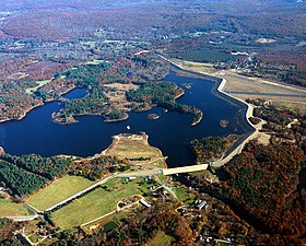
Mansfield Hollow State Park is a public recreation area occupying 251 acres (102 ha) of leased lands on the western shore of 500-acre (200 ha) Mansfield Hollow Lake in the town of Mansfield, Connecticut.[3] The state park is one portion of the 2,300 acres (930 ha) leased by the Connecticut Department of Energy and Environmental Protection from the U.S. Army Corps of Engineers for recreational and wildlife management purposes.[4] Geologic features of the park include remnants of the last glacial period, where retreating glaciers left kames, eskers, and kettles. Recreational opportunities include facilities for boating, fishing, picnicking, hiking, mountain biking, and cross-country skiing.[3] The park is traversed by the southeastern leg of the Nipmuck Trail.
References
[edit]- ^ "Appendix A: List of State Parks and Forests" (PDF). State Parks and Forests: Funding. Staff Findings and Recommendations. Connecticut General Assembly. January 23, 2014. p. A-2. Retrieved March 20, 2014.
- ^ "Mansfield Hollow State Park". Connecticut Department of Energy and Environmental Protection. Archived from the original on March 4, 2016. Retrieved October 2, 2017.
- ^ a b "Mansfield Hollow State Park". Connecticut Department of Energy and Environmental Protection. Retrieved August 20, 2024.
- ^ "Mansfield Hollow Lake". U.S. Army Corps of Engineers. June 11, 2015. Retrieved October 2, 2017.
External links
[edit]- Mansfield Hollow State Park Connecticut Department of Energy and Environmental Protection
- Mansfield Hollow State Park Map Connecticut Department of Energy and Environmental Protection


