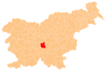
Mali Vrh pri Šmarju
Appearance
Mali Vrh pri Šmarju
Mali Vrh (until 1955) | |
|---|---|
 | |
| Coordinates: 45°58′58.2″N 14°35′56.33″E / 45.982833°N 14.5989806°E | |
| Country | |
| Traditional region | Lower Carniola |
| Statistical region | Central Slovenia |
| Municipality | Grosuplje |
| Area | |
• Total | 0.84 km2 (0.32 sq mi) |
| Elevation | 376.7 m (1,235.9 ft) |
| Population (2002) | |
• Total | 362 |
| [1] | |
Mali Vrh pri Šmarju (pronounced [ˈmaːli ˈʋəɾx pɾi ˈʃmaːɾju]; German: Kleingupf[2]) is a settlement just northwest of Šmarje–Sap in the Municipality of Grosuplje in central Slovenia. The area is part of the historical region of Lower Carniola. The municipality is now included in the Central Slovenia Statistical Region.[3]
Name
[edit]Mali Vrh was attested in historical sources as Wenigen perk in 1453.[4] The name of the settlement was changed from Mali Vrh to Mali Vrh pri Šmarju in 1955.[5]
Cultural heritage
[edit]Evidence of an Iron Age hillfort has been found on Vrhovka Hill northeast of the settlement.[6]
References
[edit]- ^ Statistical Office of the Republic of Slovenia
- ^ Leksikon občin kraljestev in dežel zastopanih v državnem zboru, vol. 6: Kranjsko. Vienna: C. Kr. Dvorna in Državna Tiskarna. 1906. p. 112.
- ^ Grosuplje municipal site
- ^ "Mali Vrh". Slovenska historična topografija. ZRC SAZU Zgodovinski inštitut Milka Kosa. Retrieved November 21, 2020.
- ^ Spremembe naselij 1948–95. 1996. Database. Ljubljana: Geografski inštitut ZRC SAZU, DZS.
- ^ "EŠD 11873". Registry of Immovable Cultural Heritage (in Slovenian). Ministry of Culture of the Republic of Slovenia. Retrieved 1 July 2011.
External links
[edit] Media related to Mali Vrh pri Šmarju at Wikimedia Commons
- Mali Vrh pri Šmarju on Geopedia


