Los Aposentos
Appearance
| Los Aposentos National Park | |
|---|---|
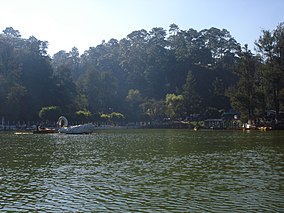
 Small lake in the park. | |
 | |
| Location | Chimaltenango (department), Guatemala |
| Coordinates | 14°38′08″N 90°48′56″W / 14.63556°N 90.81556°W |
| Area | 0.15 km2 (0.058 sq mi) |
| Elevation | 1,750 m (5,740 ft) |
| Established | Acuerdo Gubernativo 26-05-55 |
| Operator | CONAP |
Los Aposentos is a small forested park area with a number of springs and two small lakes. It is located a few kilometers south of the city of Chimaltenango in Guatemala. It was formerly known as "Finca la Alameda" and renamed to Los Aposentos in 1929.[1]
An area of 0.15 km2, including the lakes was declared a national park in 1955.[2]
References
[edit]- ^ Prensa Libre. "El Lago de los Cisnes, lugar de esparcimiento" (in Spanish). Archived from the original on 2007-05-04. Retrieved 2009-07-25.
- ^ CONAP. "Listado de Áreas Protegidas (enero, 2011)" (in Spanish). conap.gob.gt. Archived from the original (xls) on 2011-10-08. Retrieved 2011-06-14.
