List of quadrangles on Mercury
The surface of the planet Mercury has been divided into fifteen quadrangles, designated H-1 to H-15 (the 'H' stands for Hermes, the Greek equivalent of Mercury).[1] The quadrangles are named for prominent surface features visible within each area.[1] The quadrangles were initially named for albedo features, as these were the most prominent features visible before mapping was carried out by spacecraft. The mapping carried out with the images obtained by the Mariner 10 flybys in 1974 and 1975 led to nine of the quadrangles being renamed for newly mapped prominent features.[1] The remaining six quadrangles were completely unmapped by Mariner 10 and were still referred to by their albedo feature names. Following the arrival of MESSENGER in orbit in 2011, these six quadrangles were mapped and renamed.[2] The base mosaic used in the new maps was produced with orbital images by the MESSENGER Team and released by NASA’s Planetary Data System on March 8, 2013. This global mosaic includes 100% coverage of Mercury’s surface.
| Name[3] | Number | Namesake | Albedo feature name[4] | Area[5] | Mariner 10 map | Current map[3] | Notes |
|---|---|---|---|---|---|---|---|
| Borealis | H-1 | Borealis Planitia[6] | Borea | North pole to 67° latitude |  |
 |
Provisionally called "Goethe", but renamed by the International Astronomical Union in 1976 (IAU, 1977).[5] |
| Victoria | H-2 | Victoria Rupes | Aurora | 0 to 90° longitude, 21 to 66° latitude |  |
 |
|
| Shakespeare | H-3 | Shakespeare crater | Caduceata | 90 to 180° longitude, 21 to 66° latitude |  |
 |
|
| Raditladi | H-4 | Raditladi Basin | Liguria | 270 to 180° longitude, 21 to 66° latitude | none |  |
|
| Hokusai | H-5 | Hokusai crater | Apollonia | 360 to 270° longitude, 21 to 66° latitude | none |  |
|
| Kuiper | H-6 | Kuiper crater | Tricrena | 0 to 72° longitude, −22 to 22° latitude |  |
 |
|
| Beethoven | H-7 | Beethoven crater | Solitudo Lycaonis | 72 to 144° longitude, −22 to 22° latitude |  |
 |
|
| Tolstoj | H-8 | Tolstoj crater | Phaethontias | 144 to 216° longitude, −22 to 22° latitude |  |
 |
Provisionally called "Tir", but renamed by the International Astronomical Union in 1976 (IAU, 1977).[5] |
| Eminescu | H-9 | Eminescu crater | Solitudo Criophori | 216 to 288° longitude, −22 to 22° latitude | none |  |
|
| Derain | H-10 | Derain crater | Pieria | 288 to 360° longitude, –22 to 22° latitude | none |  |
|
| Discovery | H-11 | Discovery Rupes[6] | Solitudo Hermae Trismegisti | 0 to 90° longitude, −21 to −66° latitude |  |
 |
|
| Michelangelo | H-12 | Michelangelo crater | Solitudo Promethei | 90 to 180° longitude, −21 to -66° latitude |  |
 |
|
| Neruda | H-13 | Neruda crater | Solitudo Persephones | 180 to 270° longitude, −21 to –66° latitude | none |  |
|
| Debussy | H-14 | Debussy crater | Cyllene | 270 to 360° longitude, −21 to −66° latitude | none |  |
|
| Bach | H-15 | Bach crater | Australia | South pole to −67° latitude |  |
 |
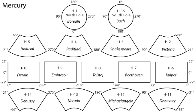
Schema of the quadrangles
[edit]Relationship of the quadrangles to each other on the surface of Mercury (North is at the top):[5]

See also
[edit]References
[edit]- ^ a b c Strom, Robert G.; Sprague, Ann L. (2003). Exploring Mercury: The Iron Planet. p. 79. ISBN 9781852337315.
- ^ "IAU Information Bulletin" (PDF) (108). International Astronomical Union. July 2011: 23.
{{cite journal}}: Cite journal requires|journal=(help) - ^ a b "1:5 Million-Scale Maps of Mercury". Gazetteer of Planetary Nomenclature (USGS/IAU/NASA). Retrieved 2021-10-24.
- ^ "SP-423 Atlas of Mercury". NASA. p. 21. Retrieved 2013-09-19.
- ^ a b c d Schaber, Gerald G.; John F. McCauley (1980). Geologic Map of the Tolstoj (H-8) Quadrangle of Mercury (PDF). U.S. Geological Survey. USGS Miscellaneous Investigations Series Map I–1199, as part of the Atlas of Mercury, 1:5,000,000 Geologic Series. Retrieved 2007-11-12.
- ^ a b "SP-423 Atlas of Mercury". NASA. Retrieved 2007-11-12.
