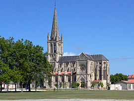
Lesparre-Médoc
You can help expand this article with text translated from the corresponding article in French. (July 2012) Click [show] for important translation instructions.
|
Lesparre-Médoc | |
|---|---|
Subprefecture and commune | |
 The church in Lesparre | |
| Coordinates: 45°18′28″N 0°56′11″W / 45.3078°N 0.9364°W | |
| Country | France |
| Region | Nouvelle-Aquitaine |
| Department | Gironde |
| Arrondissement | Lesparre-Médoc |
| Canton | Le Nord-Médoc |
| Government | |
| • Mayor (2020–2026) | Bernard Guiraud[1] |
Area 1 | 36.97 km2 (14.27 sq mi) |
| Population (2021)[2] | 5,844 |
| • Density | 160/km2 (410/sq mi) |
| Time zone | UTC+01:00 (CET) |
| • Summer (DST) | UTC+02:00 (CEST) |
| INSEE/Postal code | 33240 /33340 |
| Elevation | 7–34 m (23–112 ft) (avg. 4 m or 13 ft) |
| 1 French Land Register data, which excludes lakes, ponds, glaciers > 1 km2 (0.386 sq mi or 247 acres) and river estuaries. | |
Lesparre-Médoc (French pronunciation: [lɛspaʁ medɔk] ; Occitan: L'Esparra de Medòc, [lespaˈra ˈde meˈðɔk]), commonly known as Lesparre (L'Esparra), is a commune in the Gironde department, Nouvelle-Aquitaine, southwestern France. It is a sub-prefecture of the department.
Geography
[edit]Lesparre is on the Médoc peninsula about 80 km north of Bordeaux.
History
[edit]Traces of human occupation from the Neolithic era have been discovered in the town. Before the arrival of the Romans, the area was inhabited by the Biturges, a Celtic tribe. After the Roman Empire collapsed, various peoples such as the Arabs and Normans came into the area. During the rule of Charlemagne, a castle was built to protect the town from further invasions. In the High Middle Ages it was the site of castle. The troubadour Aimeric de Belenoi was born here. In 1790, the town was promoted to district capital. During WWII, the town was the site of guerilla warfare with German troops. During the 20th century, the infrastructure of the town was expanded and the population grew to 5,200 people.
Population
[edit]
|
| ||||||||||||||||||||||||||||||||||||||||||||||||||||||||||||||||||||||||||||||||||||||||||||||||||||||||||||||||||
| Source: EHESS[3] and INSEE (1968-2017)[4] | |||||||||||||||||||||||||||||||||||||||||||||||||||||||||||||||||||||||||||||||||||||||||||||||||||||||||||||||||||
International relations
[edit]Lesparre is twinned with Drayton in the Vale of White Horse, Oxfordshire, England.[5]
Notable persons
[edit]- Bour de Lesparre, Mercenary captain of the Hundred Years' War
Climate
[edit]| Climate data for Lesparre-Médoc (1991–2010 normals, extremes 1985–2010) | |||||||||||||
|---|---|---|---|---|---|---|---|---|---|---|---|---|---|
| Month | Jan | Feb | Mar | Apr | May | Jun | Jul | Aug | Sep | Oct | Nov | Dec | Year |
| Record high °C (°F) | 18.4 (65.1) |
23.6 (74.5) |
26.7 (80.1) |
31.5 (88.7) |
35.0 (95.0) |
38.4 (101.1) |
38.1 (100.6) |
40.9 (105.6) |
36.3 (97.3) |
31.5 (88.7) |
25.0 (77.0) |
22.0 (71.6) |
40.9 (105.6) |
| Mean daily maximum °C (°F) | 10.5 (50.9) |
11.9 (53.4) |
15.3 (59.5) |
17.3 (63.1) |
21.6 (70.9) |
24.7 (76.5) |
26.3 (79.3) |
27.0 (80.6) |
23.7 (74.7) |
19.3 (66.7) |
13.9 (57.0) |
10.7 (51.3) |
18.5 (65.3) |
| Daily mean °C (°F) | 6.7 (44.1) |
7.2 (45.0) |
10.0 (50.0) |
11.8 (53.2) |
15.8 (60.4) |
18.7 (65.7) |
20.2 (68.4) |
20.6 (69.1) |
17.6 (63.7) |
14.4 (57.9) |
9.7 (49.5) |
7.1 (44.8) |
13.3 (55.9) |
| Mean daily minimum °C (°F) | 2.9 (37.2) |
2.6 (36.7) |
4.6 (40.3) |
6.3 (43.3) |
10.0 (50.0) |
12.7 (54.9) |
14.2 (57.6) |
14.3 (57.7) |
11.5 (52.7) |
9.5 (49.1) |
5.5 (41.9) |
3.4 (38.1) |
8.1 (46.6) |
| Record low °C (°F) | −17.0 (1.4) |
−10.5 (13.1) |
−10.3 (13.5) |
−4.1 (24.6) |
−0.1 (31.8) |
2.5 (36.5) |
6.0 (42.8) |
5.0 (41.0) |
2.2 (36.0) |
−3.4 (25.9) |
−7.5 (18.5) |
−10.1 (13.8) |
−17.0 (1.4) |
| Average precipitation mm (inches) | 90.1 (3.55) |
64.3 (2.53) |
60.1 (2.37) |
65.4 (2.57) |
60.5 (2.38) |
61.3 (2.41) |
41.8 (1.65) |
50.0 (1.97) |
71.6 (2.82) |
90.1 (3.55) |
117.3 (4.62) |
99.7 (3.93) |
872.2 (34.34) |
| Average precipitation days (≥ 1.0 mm) | 12.6 | 10.9 | 10.4 | 10.8 | 9.6 | 8.0 | 7.2 | 7.4 | 8.6 | 12.0 | 14.2 | 13.4 | 125.1 |
| Source: Meteociel[6] | |||||||||||||
See also
[edit]References
[edit]- ^ "Répertoire national des élus: les maires". data.gouv.fr, Plateforme ouverte des données publiques françaises (in French). 2 December 2020.
- ^ "Populations légales 2021" (in French). The National Institute of Statistics and Economic Studies. 28 December 2023.
- ^ Des villages de Cassini aux communes d'aujourd'hui: Commune data sheet Lesparre-Médoc, EHESS (in French).
- ^ Population en historique depuis 1968, INSEE
- ^ "Subventions à la baisse, la grogne des associations". sudouest.fr. Retrieved 9 April 2018.
- ^ "Normales et records pour Lesparre Medoc (33)". Meteociel. Retrieved 22 November 2024.


