Gujan-Mestras
Gujan-Mestras | |
|---|---|
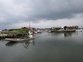
 Oyster port | |
| Coordinates: 44°38′11″N 1°04′00″W / 44.6364°N 1.0667°W | |
| Country | France |
| Region | Nouvelle-Aquitaine |
| Department | Gironde |
| Arrondissement | Arcachon |
| Canton | Gujan-Mestras |
| Intercommunality | CA Bassin d'Arcachon Sud |
| Government | |
| • Mayor (2020–2026) | Marie-Hélène des Esgaulx[1] |
| Area 1 | 53.99 km2 (20.85 sq mi) |
| Population (2021)[2] | 22,399 |
| • Density | 410/km2 (1,100/sq mi) |
| Time zone | UTC+01:00 (CET) |
| • Summer (DST) | UTC+02:00 (CEST) |
| INSEE/Postal code | 33199 /33470 |
| Elevation | 0–28 m (0–92 ft) (avg. 4 m or 13 ft) |
| 1 French Land Register data, which excludes lakes, ponds, glaciers > 1 km2 (0.386 sq mi or 247 acres) and river estuaries. | |
Gujan-Mestras (French pronunciation: [ɡyʒɑ̃ mɛstʁas]; Occitan: Gujan e Mestràs) is a commune in the Gironde department in southwestern France. It is twinned with Santa María de Cayón, Spain
Population
[edit]
|
| ||||||||||||||||||||||||||||||||||||||||||||||||||||||||||||||||||||||||||||||||||||||||||||||||||||||||||||||||||
| |||||||||||||||||||||||||||||||||||||||||||||||||||||||||||||||||||||||||||||||||||||||||||||||||||||||||||||||||||
| Source: EHESS[3] and INSEE (1968-2017)[4] | |||||||||||||||||||||||||||||||||||||||||||||||||||||||||||||||||||||||||||||||||||||||||||||||||||||||||||||||||||
Geography
[edit]Gujan-Mestras is located in the southern part of the Arcachon bay. It is considered a major regional center for oyster farming, and is home to seven ports, which are from west to east:[5]
- The Port of La Hume which focuses both on oyster farming and yachting,
- The Port of Meyran,
- The Port of Gujan,
- The Port of Larros which offers a promenade pier and is an active center for shipbuilding,
- The Port of the Canal,
- The Port of La Barbotière, a major oyster farming center close to the Technical High School for Maritime Science and Technologies
- The Port of La Mole which has neither been dredged nor used due to its difficult topography. From the former windmill bordering the port, only a millstone has withstood time. It gave its name to the Port of La Mole, “mole” meaning millstone in Gascon.
Neighbouring communes
[edit]Gujan-Mestras is surrounded by three communes. It is west of Le Teich, east of La Teste-de-Buch and north of Sanguinet.

Transports
[edit]The TER Nouvelle-Aquitaine from Arcachon to Bordeaux has two stops in Gujan-Mestras (respectively named La Hume and Gujan-Mestras). The city is otherwise served by lines 4 to 7 of the Baïa bus network, the local public transport system of the Arcachon Bay which links the Dune of Pilat to Facture-Biganos.[6] Nearest airport is Bordeaux–Mérignac Airport, around 50 km away.
-
La Hume train station.
-
Gujan-Mestras main train station.
Twin towns – sister cities
[edit] Santa María de Cayón, Spain, autonomous community Cantabria
See also
[edit]References
[edit]- ^ "Répertoire national des élus: les maires" (in French). data.gouv.fr, Plateforme ouverte des données publiques françaises. 13 September 2022.
- ^ "Populations légales 2021" (in French). The National Institute of Statistics and Economic Studies. 28 December 2023.
- ^ Des villages de Cassini aux communes d'aujourd'hui: Commune data sheet Gujan-Mestras, EHESS (in French).
- ^ Population en historique depuis 1968, INSEE
- ^ "Vie maritime". ville-gujanmestras.fr.
- ^ "Se déplacer".


