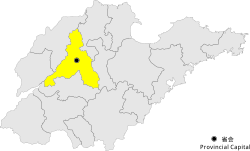
Laiwu, Jinan
Appearance
Laiwu
莱芜区 | |
|---|---|
 Location in the city of Jinan | |
 Jinan city in Shandong | |
| Country | People's Republic of China |
| Province | Shandong |
| Prefecture-level city | Jinan |
| Area | |
• District | 1,909.89 km2 (737.41 sq mi) |
| • Metro | 2,246.43 km2 (867.35 sq mi) |
| Population (2010 census) | |
• District | 989,535 |
| • Density | 520/km2 (1,300/sq mi) |
| • Metro | 1,298,529 |
| • Metro density | 580/km2 (1,500/sq mi) |
| Time zone | UTC+8 (China Standard) |
| Postal code | 271100 |
| Area code | +86 0634 |
| Website | www |
Laiwu District (simplified Chinese: 莱芜区; traditional Chinese: 萊蕪區; pinyin: Láiwú Qū) is one of 10 urban districts of the prefecture-level city of Jinan, the capital of Shandong Province, East China.
It has an area of 1,906.89 km2 (736.25 sq mi) and 989,535 inhabitants as of 2010 census. Nevertheless, its built-up area made of Laiwu District and Gangcheng District (the previous Laiwu city) was home to 1,298,529 inhabitants.
In January 2019, the Shandong provincial government announced in a decision that Laiwu Prefecture-level City was absorbed by Jinan. Laicheng District was renamed to Laiwu District under Jinan's administration.
Administrative divisions
[edit]As 2012, Laicheng District is divided to 4 subdistricts, 10 towns and 1 townships.[1]
- Subdistricts
|
|
- Towns
|
|
- Townships
- Hezhuang Township (和庄乡)
Climate
[edit]| Climate data for Laiwu District (1991–2020 normals, extremes 1981–2010) | |||||||||||||
|---|---|---|---|---|---|---|---|---|---|---|---|---|---|
| Month | Jan | Feb | Mar | Apr | May | Jun | Jul | Aug | Sep | Oct | Nov | Dec | Year |
| Record high °C (°F) | 17.3 (63.1) |
21.1 (70.0) |
28.5 (83.3) |
32.9 (91.2) |
36.2 (97.2) |
38.7 (101.7) |
39.9 (103.8) |
36.6 (97.9) |
35.7 (96.3) |
33.9 (93.0) |
25.0 (77.0) |
18.5 (65.3) |
39.9 (103.8) |
| Mean daily maximum °C (°F) | 3.9 (39.0) |
7.5 (45.5) |
13.8 (56.8) |
21.0 (69.8) |
26.6 (79.9) |
30.5 (86.9) |
31.2 (88.2) |
30.0 (86.0) |
26.3 (79.3) |
20.4 (68.7) |
12.4 (54.3) |
5.5 (41.9) |
19.1 (66.4) |
| Daily mean °C (°F) | −1.4 (29.5) |
1.9 (35.4) |
7.9 (46.2) |
14.9 (58.8) |
20.8 (69.4) |
25.0 (77.0) |
26.6 (79.9) |
25.4 (77.7) |
21.0 (69.8) |
14.7 (58.5) |
7.1 (44.8) |
0.5 (32.9) |
13.7 (56.7) |
| Mean daily minimum °C (°F) | −5.4 (22.3) |
−2.5 (27.5) |
2.8 (37.0) |
9.4 (48.9) |
15.2 (59.4) |
19.8 (67.6) |
22.7 (72.9) |
21.6 (70.9) |
16.6 (61.9) |
10.0 (50.0) |
2.9 (37.2) |
−3.3 (26.1) |
9.2 (48.5) |
| Record low °C (°F) | −19.3 (−2.7) |
−17.0 (1.4) |
−10.3 (13.5) |
−3.8 (25.2) |
2.4 (36.3) |
9.6 (49.3) |
12.7 (54.9) |
12.0 (53.6) |
6.3 (43.3) |
−3.6 (25.5) |
−12.4 (9.7) |
−18.0 (−0.4) |
−19.3 (−2.7) |
| Average precipitation mm (inches) | 5.6 (0.22) |
11.8 (0.46) |
13.1 (0.52) |
30.2 (1.19) |
54.5 (2.15) |
94.3 (3.71) |
190.3 (7.49) |
183.9 (7.24) |
69.1 (2.72) |
28.1 (1.11) |
25.2 (0.99) |
8.5 (0.33) |
714.6 (28.13) |
| Average precipitation days (≥ 0.1 mm) | 2.5 | 3.5 | 3.6 | 5.6 | 6.8 | 8.3 | 12.7 | 12.5 | 7.4 | 5.7 | 4.5 | 3.4 | 76.5 |
| Average snowy days | 4.0 | 3.1 | 1.7 | 0.3 | 0 | 0 | 0 | 0 | 0 | 0 | 1.2 | 2.6 | 12.9 |
| Average relative humidity (%) | 56 | 53 | 49 | 50 | 54 | 59 | 74 | 76 | 69 | 63 | 62 | 59 | 60 |
| Mean monthly sunshine hours | 158.4 | 159.8 | 207.1 | 228.0 | 250.7 | 212.5 | 175.7 | 180.5 | 184.3 | 189.6 | 161.7 | 158.4 | 2,266.7 |
| Percent possible sunshine | 51 | 52 | 56 | 58 | 57 | 49 | 40 | 44 | 50 | 55 | 53 | 53 | 52 |
| Source: China Meteorological Administration[2][3] | |||||||||||||
Notable villages
[edit]References
[edit]- ^ 东营市-行政区划网 www.xzqh.org (in Chinese). XZQH. Retrieved 2012-05-24.
- ^ 中国气象数据网 – WeatherBk Data (in Simplified Chinese). China Meteorological Administration. Retrieved 12 August 2023.
- ^ 中国气象数据网 (in Simplified Chinese). China Meteorological Administration. Retrieved 12 August 2023.
