Kwakoegron
Appearance
Kwakoegron | |
|---|---|
Resort | |
 Former train station of Kwakoegron (1947) | |
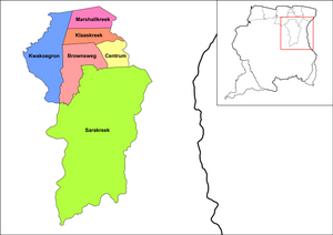
 Map showing the resorts of Brokopondo District. Kwakoegron | |
| Coordinates: 5°14′53″N 55°20′41″W / 5.24806°N 55.34472°W | |
| Country | |
| District | Brokopondo |
| Area | |
| • Total | 1,050 km2 (410 sq mi) |
| Population (1 January 2012)[1] | |
| • Total | 263 |
| • Density | 0.25/km2 (0.65/sq mi) |
| Time zone | UTC-3 (AST) |
Kwakoegron (land of Kwakoe) is a town and resort in Suriname. It is located inland, due south of Paramaribo. According to the 2012 census it has a population of 263, and is mainly inhabited by Maroons,[1] of the Matawai people.[2] The resort and town are named after Kwakoe, the native word for Wednesday, and grond, the Dutch word for ground.[3] The captain of the resort resides in the village Commisariskondre.[2]
Overview
[edit]Kwakoegron has a school, a clinic, and a holiday resort.[2] The resort can be accessed via a paved side road of the Southern East-West Link[4] In 1910, Kwakoegron was connected to the Lawa Railway which closed in 1987.[5]
The Brinckheuvel Nature Reserve is located near the village.[6]
See also
[edit]References
[edit]- ^ a b "Resorts in Suriname Census 2012" (PDF). Retrieved 21 May 2020.
- ^ a b c "Structuur Analyse" (PDF). Planning Office Suriname (in Dutch). Retrieved 25 May 2020.
- ^ "Encyclopaedie van Nederlandsch West-Indië - Page 448 - Lelydorp" (PDF). Digital Library for Dutch Literature (in Dutch). 1916. Retrieved 5 May 2020.
- ^ "Asfaltering wegstrekking Pikin Saron – Kwakoegron afgerond". GFC Nieuws (in Dutch). Retrieved 21 May 2020.
- ^ "De flop van Lely". Parbode (in Dutch). 2 April 2008. Retrieved 13 May 2020.
- ^ Ouboter, Paul E. (2001). "Directory of protected areas of Suriname". IBER. p. 71.
External links
[edit]Wikimedia Commons has media related to Kwakoegron.

