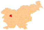
Kremenik
Appearance
Kremenik | |
|---|---|
 | |
| Coordinates: 46°5′28.17″N 14°12′6.13″E / 46.0911583°N 14.2017028°E | |
| Country | |
| Traditional region | Upper Carniola |
| Statistical region | Upper Carniola |
| Municipality | Gorenja Vas–Poljane |
| Area | |
| • Total | 1.59 km2 (0.61 sq mi) |
| Elevation | 713.5 m (2,340.9 ft) |
| Population (2020) | |
| • Total | 19 |
| • Density | 12/km2 (31/sq mi) |
| [1] | |
Kremenik (pronounced [kɾɛˈmeːnik]) is a small dispersed settlement in the hills south of Poljane nad Škofjo Loko in the Municipality of Gorenja Vas–Poljane in the Upper Carniola region of Slovenia.[2]
References
[edit]- ^ Statistical Office of the Republic of Slovenia Archived November 18, 2008, at the Wayback Machine
- ^ Gorenja Vas–Poljane municipal site
External links
[edit] Media related to Kremenik at Wikimedia Commons
- Kremenik on Geopedia


