Kimongo District
Appearance
(Redirected from Kimongo)
Kimongo | |
|---|---|
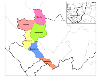
 Kimongo District in the region | |
| Country | |
| Region | Niari Region |
| Area | |
• Total | 530 sq mi (1,360 km2) |
| Population (2023 census)[1] | |
• Total | 18,929 |
| • Density | 36/sq mi (14/km2) |
| Time zone | UTC+1 (GMT +1) |
Kimongo is a district in the Niari Region of south-western Republic of the Congo. The capital lies at Kimongo. The district shares a southern border with the Angolan Enclave of Cabinda Province.[2]
Demographics
[edit]A 2007 census estimated the population to be 19,578.[3]
References
[edit]- ^ "Congo (Rep.): Administrative Division". www.citypopulation.de. Retrieved 2024-02-03.
- ^ "Angolan troops enter Congo, 'kidnap soldiers'". 18 October 2013.
- ^ "The Republic of the Congo". GeoHive. Archived from the original on May 22, 2012.
4°32′S 13°12′E / 4.533°S 13.200°E

