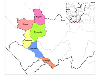
Mayoko District
Appearance
Mayoko | |
|---|---|
 Mayoko District in the region | |
| Country | |
| Department | Niari Department |
| Area | |
| • Total | 1,300 sq mi (3,368 km2) |
| Population (2023 census)[1] | |
| • Total | 8,098 |
| • Density | 6.2/sq mi (2.4/km2) |
| Time zone | UTC+1 (GMT +1) |
Mayoko District is a district in the Niari Department of south-western Republic of the Congo.[2] The capital lies at Mayoko. It has a northern border with Gabon. As of 2007, the population is 5,147.[3]
Transport
[edit]Mayoko is served by a branch railway of the Congo–Ocean Railway that terminates in Mbinda. It lies near the border with Gabon.
Mining
[edit]Mayoko is near deposits of iron ore, which are very close to an existing railway line leading to a port.
See also
[edit]- Railway stations in the Republic of the Congo
- Iron ore in Africa
References
[edit]- ^ "Congo (Rep.): Administrative Division". www.citypopulation.de. Retrieved 2024-02-03.
- ^ "Annuaire Statistique du Congo 2009" (PDF) (in French). Centre National de la Statistique et des Études Économiques (CNSEE). 2011. p. 6. Retrieved 3 June 2012.
- ^ "Population des Départements" (PDF) (in French). Centre National de la Statistique et des Études Économiques (CNSEE). 2011. Retrieved 3 June 2012.
02°19′30″S 12°47′51″E / 2.32500°S 12.79750°E

