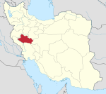
Kakavand District
Appearance
Kakavand District
Persian: بخش کاکاوند | |
|---|---|
| Coordinates: 34°12′52″N 47°39′58″E / 34.21444°N 47.66611°E[1] | |
| Country | Iran |
| Province | Lorestan |
| County | Delfan |
| Capital | Haft Cheshmeh |
| Population (2016)[2] | |
| • Total | 19,127 |
| Time zone | UTC+3:30 (IRST) |
Kakavand District (Persian: بخش کاکاوند) is in Delfan County, Lorestan province, Iran. Its capital is the city of Haft Cheshmeh.[3] After the 2006 National Census, the village of Haft Cheshmeh was elevated to the status of a city.[4] In March 2022, Itivand-e Jonubi and Itivand-e Shomali Rural Districts were separated from the district in the establishment of Itivand District.[5]
Demographics
[edit]At the time of the 2006 census, the district's population was 23,598 in 4,574 households.[6] The following census in 2011 counted 21,837 people in 5,172 households.[7] The 2016 census measured the population of the district as 19,127 inhabitants in 5,284 households.[2]
| Administrative Divisions | 2006[6] | 2011[7] | 2016[2] |
|---|---|---|---|
| Itivand-e Jonubi RD[a] | 6,400 | 5,864 | 5,150 |
| Itivand-e Shomali RD[a] | 3,126 | 2,923 | 2,918 |
| Kakavand-e Gharbi RD | 5,831 | 5,044 | 4,611 |
| Kakavand-e Sharqi RD | 8,241 | 6,958 | 5,578 |
| Haft Cheshmeh (city) | 1,048 | 870 | |
| Total | 23,598 | 21,837 | 19,127 |
| RD = Rural District | |||
See also
[edit]Notes
[edit]- ^ a b Transferred to Itivand District after the 2016 census[5]
References
[edit]- ^ OpenStreetMap contributors (24 August 2023). "Kakavand District (Delfan County)" (Map). OpenStreetMap (in Persian). Retrieved 24 August 2023.
- ^ a b c "Census of the Islamic Republic of Iran, 1395 (2016)". AMAR (in Persian). The Statistical Center of Iran. p. 15. Archived from the original (Excel) on 12 October 2020. Retrieved 19 December 2022.
- ^ Mousavi, Mirhossein. "Creation of Delfan County under the citizenship of Lorestan province and creation of Kakavand District". Lamtakam (in Persian). Ministry of Interior, Council of Ministers. Archived from the original on 21 January 2024. Retrieved 21 January 2024.
- ^ Rahimi, Mohammad Reza (13 August 2019). "With seven changes in the geography of several provinces of the country: Six new cities were added to the map of country divisions". DOLAT (in Persian). Ministry of Interior, Political and Defense Commission. Archived from the original on 3 August 2020. Retrieved 2 April 2023.
- ^ a b "Itivand in the path of construction and development: the need to establish representative offices". Mehr News (in Persian). Ministry of Interior, Board of Ministers. 25 February 2023. Archived from the original on 23 August 2023. Retrieved 23 August 2023.
- ^ a b "Census of the Islamic Republic of Iran, 1385 (2006)". AMAR (in Persian). The Statistical Center of Iran. p. 15. Archived from the original (Excel) on 20 September 2011. Retrieved 25 September 2022.
- ^ a b "Census of the Islamic Republic of Iran, 1390 (2011)". Syracuse University (in Persian). The Statistical Center of Iran. p. 15. Archived from the original (Excel) on 19 January 2023. Retrieved 19 December 2022.


