Kairatu
Appearance
Kairatu | |
|---|---|
Kecamatan and town | |
| Coordinates: 3°12′55″S 128°10′34″E / 3.21528°S 128.17611°E | |
| Country | Indonesia |
| Province | Maluku |
| Regency | West Seram |
| Area | |
• Total | 329.65 km2 (127.28 sq mi) |
| Population (2020 Census)[1] | |
• Total | 26,717 |
| Time zone | UTC+8 (WITA) |
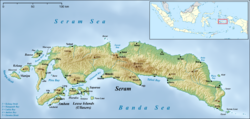
Kairatu is a small town and district (kecamatan) on the southwestern coast of the Indonesian island of Seram.[2] It is part of West Seram Regency. According to the 2010 census, the district had a population of 54,866 people, but the district has subsequently been split and the reduced area (now 329.65 km2) had 27,040 inhabitants at the 2020 Census, while the official estimate as at mid 2023 was 26,717.[3] The town itself had 10,266 inhabitants in mid 2022.[4]
References
[edit]- ^ Badan Pusat Statistik, Jakarta, 2024.
- ^ "Seram Island (map)". Indonesiatravelingguide.com. Retrieved 8 June 2015.
- ^ Badan Pusat Statistik, Jakarta, 2024.
- ^ Badan Pusat Statistik, Jakarta, 2023.

