Bemu
Appearance
Bemu | |
|---|---|
Town | |
| Coordinates: 3°24′15″S 129°58′29″E / 3.40417°S 129.97472°E | |
| Country | Indonesia |
| Province | Maluku |
| Time zone | UTC+8 (WITA) |
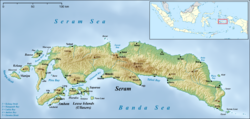
Bemu, also Bemo Perak, is a small town on the southeastern coast of the Indonesian island of Seram, just to the south of Atiahu.[1] It is one of the principal settlements on Teluti Bay.[2]
References
[edit]- ^ "Seram Island (map)". Indonesiatravelingguide.com. Archived from the original on 24 September 2015. Retrieved 8 June 2015.
- ^ Prostar Sailing Directions 2004 New Guinea Enroute. ProStar Publications. 1 January 2004. p. 56. ISBN 978-1-57785-569-9.

