Jovsa

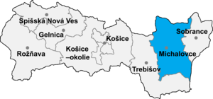
Jovsa (Hungarian: Jósza) is a village and municipality in Michalovce District in the Kosice Region of eastern Slovakia.
History
[edit]In historical records the village was first mentioned in 1418. Before the establishment of independent Czechoslovakia in 1918, it was part of Ung County within the Kingdom of Hungary.
Geography
[edit]The village lies at an altitude of 138 metres and covers an area of 18.44 km2 (7.12 sq mi) (2020-06-30/-07-01).[1]
Population
[edit]It has a population of 830 people (2020-12-31).[2]
Ethnicity
[edit]The population is about 99% Slovak in ethnicity.
Culture
[edit]The village has a small public library, a post office, a football pitch and a food store.
Genealogical resources
[edit]The records for genealogical research are available at the state archive "Statny Archiv in Presov, Slovakia":
- Greek Catholic church records (births/marriages/deaths): 1767-1914 (parish A)
Gallery
[edit]-
Main street in Jovsa
-
The Vihorlat Mountains seen from Jovsa
-
Dyke of the Zemplínska Šírava reservoir on the outskirts of Jovsa, with footpath
-
The Zemplínska Šírava reservoir from the shore in Jovsa, Medvedia hora peninsula seen in distance
See also
[edit]Population
[edit]| Population development[3] | |||||
|---|---|---|---|---|---|
| Year | 1994 | 1999 | 2014 | 2019 | 2020 |
| Pop. | 834 | 824 | 836 | 829 | 800 |
| ±% | — | −1.2% | +1.5% | −0.8% | −3.5% |
| Data are year-end. The time zone is CET. | |||||
References
[edit]- ^ "Statistic of Slovak places by Dušan Kreheľ – Export". Archived from the original on 2021-06-27. Retrieved 2021-07-05.
- ^ "Statistic of Slovak places by Dušan Kreheľ – Export". Archived from the original on 2021-06-09. Retrieved 2021-07-05.
- ^ "Statistic of Slovak places by Dušan Kreheľ – Export". Retrieved 2021-06-27.
External links
[edit]- https://web.archive.org/web/20071027094149/http://www.statistics.sk/mosmis/eng/run.html
- Surnames of living people in Jovsa
48°50′N 22°06′E / 48.833°N 22.100°E


