Jastrabie pri Michalovciach
You can help expand this article with text translated from the corresponding article in Slovak. Click [show] for important translation instructions.
|
Jastrabie pri Michalovciach | |
|---|---|
Village and Municipality | |
 | |
| Country | |
| Region | Košice |
| District | Michalovce |
| First mentioned | 1337 |
| Government | |
| • Mayor | Milan Kočiško (Hlas–SD) |
| Area | |
• Total | 5.74 km2 (2.22 sq mi) |
| Elevation | 104 m (341 ft) |
| Population (2023) | |
• Total | 289 |
| • Density | 50/km2 (130/sq mi) |
| Area code | +421-56 |

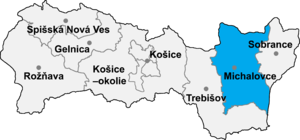
Jastrabie pri Michalovciach (Slovak pronunciation: [ˈjastrabɪe pri ˈmixalɔwtsɪɐx]; Hungarian: Alsókánya) is a village and municipality in Michalovce District in the Kosice Region of eastern Slovakia.
History
[edit]In historical records the village was first mentioned in 1337. Before the establishment of independent Czechoslovakia in 1918, it was part of Ung County within the Kingdom of Hungary.
Geography
[edit]The village lies at an elevation of 104 metres and covers an area of 5.74 km2 (2.22 sq mi) (2020-06-30/-07-01).[1]
Ethnicity
[edit]The population is about 99% Slovak in ethnicity.
Culture
[edit]The village has a small public library, a football pitch and a food store.
Notable people
[edit]- Steve Ihnat, actor and director
Genealogical resources
[edit]The records for genealogical research are available at the state archive "Statny Archiv in Presov, Slovakia"
- Roman Catholic church records (births/marriages/deaths): 1863–1926 (parish B)
- Greek Catholic church records (births/marriages/deaths): 1811–1898 (parish B)
See also
[edit]References
[edit]- ^ "Statistic of Slovak places by Dušan Kreheľ – Export". Archived from the original on 2021-06-27. Retrieved 2021-07-05.
External links
[edit]- https://web.archive.org/web/20070513023228/http://www.statistics.sk/mosmis/eng/run.html
- Surnames of living people in Jastrabie pri Michalovciach
48°42′45″N 22°01′45″E / 48.71250°N 22.02917°E
