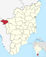
Ithalar
Appearance
Ithalar | |
|---|---|
village | |
 | |
| Country | |
| State | Tamil Nadu |
| District | Nilgiris |
| Languages | |
| • Official | Tamil |
| Time zone | UTC+5:30 (IST) |
| Vehicle registration | TN-43 |
| Coastline | 0 kilometres (0 mi) |
| Nearest city | ooty |
Ithalar is a village in the Kundah Taluk of Nilgiris district in Tamil Nadu. It is about 16 kilometres from Ooty. The main cultivation in Ithalar is tea growing and agriculture with carrot cultivation being the main occupation.[1] It has a population of 1,500 with 350 houses.
References
[edit]- ^ Radhakrishnan, D. (7 June 2013). "Carrots remain favourite of Ooty farmers". The Hindu. ISSN 0971-751X. Retrieved 19 October 2022.
11°20′34″N 76°38′10″E / 11.3429°N 76.6360°E

