Hradčovice
Hradčovice | |
|---|---|
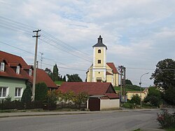
 Church of All Saints | |
| Coordinates: 49°2′59″N 17°34′56″E / 49.04972°N 17.58222°E | |
| Country | |
| Region | Zlín |
| District | Uherské Hradiště |
| First mentioned | 1247 |
| Area | |
• Total | 9.27 km2 (3.58 sq mi) |
| Elevation | 198 m (650 ft) |
| Population (2024-01-01)[1] | |
• Total | 980 |
| • Density | 110/km2 (270/sq mi) |
| Time zone | UTC+1 (CET) |
| • Summer (DST) | UTC+2 (CEST) |
| Postal code | 687 33 |
| Website | www |
Hradčovice (German: Radischowitz) is a municipality and village in Uherské Hradiště District in the Zlín Region of the Czech Republic. It has about 1,000 inhabitants.
Administrative parts
[edit]The village of Lhotka is an administrative part of Hradčovice.
Geography
[edit]Hradčovice is located about 8 kilometres (5 mi) east of Uherské Hradiště and 20 km (12 mi) south of Zlín. It lies in the Vizovice Highlands. The highest point is the hill Rovná hora at 351 m (1,152 ft) above sea level. The municipality is situated on the right bank of the Olšava River.
History
[edit]The first written mention of Hradčovice is from 1247,[2] when Duke Ulrich III donated part of the village to the church. The village of Lhotka was first mentioned in 1374. From the 15th century until the early 17th century, the estate was owned by the Lords of Kunovice. At the beginning of the 17th century, the estate was bought by the Kaunitz family, which owned it until the end of the 18th century.[3]
Demographics
[edit]
|
|
| ||||||||||||||||||||||||||||||||||||||||||||||||||||||
| Source: Censuses[4][5] | ||||||||||||||||||||||||||||||||||||||||||||||||||||||||
Transport
[edit]
The I/50 road (part of the European route E50), which connects Brno with the Czech-Slovak border in Starý Hrozenkov via Uherské Hradiště, passes through the southern part of the municipality.
Hradčovice is located on the railway line Staré Město–Bylnice.[6]
Sights
[edit]The main landmark of Hradčovice is the Church of All Saints. It was built in the early Baroque style around 1670, but it has a medieval core from the second half fof the 13th century. The church was modified to its present form after 1757.[7]
References
[edit]- ^ "Population of Municipalities – 1 January 2024". Czech Statistical Office. 2024-05-17.
- ^ Trubačík, Vojtěch (2017-01-14). "Přes patnáct historiků připravuje knihu o Hradčovicích. Vyjít má na výročí obce" (in Czech). Deník.cz. Retrieved 2024-04-04.
- ^ "Historie obce" (in Czech). Obec Hradčovice. Retrieved 2024-04-04.
- ^ "Historický lexikon obcí České republiky 1869–2011" (in Czech). Czech Statistical Office. 2015-12-21.
- ^ "Population Census 2021: Population by sex". Public Database. Czech Statistical Office. 2021-03-27.
- ^ "Detail stanice Hradčovice" (in Czech). České dráhy. Retrieved 2024-04-04.
- ^ "Kostel Všech svatých" (in Czech). National Heritage Institute. Retrieved 2024-04-04.


