Hoburg Shoal
Appearance
Hoburg Shoal
Hoburgs bank | |
|---|---|
| Coordinates: 56°47′N 18°10′E / 56.783°N 18.167°E | |
| Country | Sweden |
| County | Gotland County |
| Sea | Baltic Sea |
| Minimum depth | 10 m (33 ft) |
| Area | |
| • Total | 1,226.28 km2 (473.47 sq mi) |
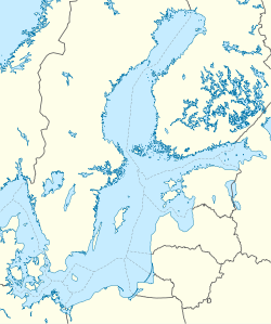
Hoburg Shoal, also known as Hoburgs bank,[2] is a shoal located in the Baltic Sea, in the southern zone of the Gotland shelf, south of Hoburgen.
The shoal is a bird reserve encompassing about 1,226.28 km2 (473.47 sq mi).[2]
Geography
[edit]It is a long shoal, comprising a northern and a southern section, that lies to the south of the Storsudret peninsula in Sundre socken on the southern tip of Gotland, Sweden.[3][4] The submerged shoal's water depths range between about 15 and 40 metres (49 and 131 ft).[5]
History
[edit]As of 2016[update], a pipeline is projected that may cross the area of the shoal.[citation needed]
References
[edit]- ^ Sailing Directions, Baltic Sea, p. 147
- ^ a b "Hoburgs bank – Protected Planet". Archived from the original on 2016-09-14. Retrieved 2016-09-01.
- ^ Google Earth
- ^ Geologiska Föreningen i Stockholm Förhandlingar Volume 87, 1965 – Issue 3; Nielsens grund och Hoburgs bank i östersjön
- ^ "MP Atlas; Hoburgs Bank Special Protection Areas (Birds Directive)". Archived from the original on 2016-09-23. Retrieved 2016-09-01.
External links
[edit]


