Västerhejde
Västerhejde
Västahaide(Gutnish) | |
|---|---|
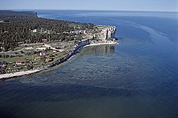
 Västerhejde coastline with Högklint cliff | |
| Coordinates: 57°35′N 18°15′E / 57.583°N 18.250°E | |
| Country | Sweden |
| Province | Gotland |
| County | Gotland County |
| Municipality | Gotland Municipality |
| Area | |
• Total | 0.53 km2 (0.20 sq mi) |
| Population (31 December 2014)[2] | |
• Total | 2,306 |
| Time zone | UTC+1 (CET) |
| • Summer (DST) | UTC+2 (CEST) |
Västerhejde is a locality on the Swedish island of Gotland.
Västerhejde is also the name of the larger populated area, socken (not to be confused with parish).[3] It comprises the same area as the administrative Västerhejde District, established on 1 January 2016.[4]
Geography
[edit]Västerhejde is the name of the locality surrounding the medieval Västerhejde Church,[5] sometimes referred to as Västerhejde kyrkby. It is also the name of the socken as well as the district. Västerhejde is located along the coast in the mid-west part of Gotland.[6] As of 2019[update], Västerhejde Church belongs to Stenkumla parish, along with the churches in Stenkumla, Träkumla and Vibble.[7][8]
Located within Västerhejde socken are Vibble, Bjärs, Nygårds fishing village with an adjacent manor and sheep farm, as well as Högklint, a small settlement by the coast. Högklint is also the name of the high cliff with an almost vertical 48 m (157 ft) drop down to the sea. There are several small caves in the steep cliff side.[9][10][11][12]
One of the asteroids in the asteroid belt, 10554 Västerhejde, is named after this place.[13]
References
[edit]- ^ "Tätorternas landareal, folkmängd och invånare per km2 2005 och 2010" (in Swedish). Statistics Sweden. 14 December 2011. Archived from the original on 2012-01-27. Retrieved 10 January 2012.
- ^ "Gotland i siffror 2015" [Gotland in numbers 2015]. www.gotland.se. Gotland Municipality. Retrieved 25 May 2016.
- ^ The exact extent of the socken, now district, can be obtained by clicking on Kartinställningar and check the Socken box in the menu of this map from the Swedish National Heritage Board database.
- ^ "Förordning om district" [Regulation of districts] (PDF). Ministry of Finance. 17 June 2015. Retrieved 25 May 2016.
- ^ Jacobsson, Britta; Johansson, Eva; Johansson, Per; Andersson, Rolf (1990). Våra kyrkor [Our churches] (in Swedish). Västervik: Klarkullens förlag AB. p. 682. ISBN 91-971561-0-8. SELIBR 7794694.
- ^ "Västerhejde". www.ne.se. Nationalencyklopedin. Retrieved 31 May 2016.
- ^ "Församlingar på Gotland". www.svenskakyrkan.se. Church of Sweden. Retrieved 12 January 2019.
- ^ "Visby stifts indelning 2018". www.svenskakyrkan.se. Church of Sweden. Retrieved 12 January 2019.
- ^ "Nygårds Herrgård". www.gotland.com. Inspiration Gotland. Retrieved 31 July 2016.
- ^ Henriksson, Greta. "Västerhejde Nygårds 1:209". www.gotland.se. Gotland County Administrative Board. Retrieved 31 July 2016.
- ^ Enderborg, Bernt. "Högklint". www.guteinfo.com. Guteinfo. Retrieved 31 July 2016.
- ^ "Småorter 2015". www.scb.se. Statistics Sweden. Retrieved 5 January 2019.
- ^ "10554 Vasterhejde (1993 FO34)". NASA. Retrieved 24 June 2016.
External links
[edit] Media related to Västerhejde at Wikimedia Commons
- Objects from Västerhejde at the Digital Museum by Nordic Museum


