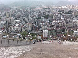
Heping County
Appearance
Heping
和平县 | |
|---|---|
 | |
| Coordinates: 24°26′N 115°00′E / 24.433°N 115.000°E | |
| Country | People's Republic of China |
| Province | Guangdong |
| Prefecture-level city | Heyuan |
| Area | |
• Total | 2,311 km2 (892 sq mi) |
| Population (2020) | |
• Total | 353,903 |
| • Density | 150/km2 (400/sq mi) |
| Time zone | UTC+8 (China Standard) |

Heping (Chinese: 和平; Jyutping: wo4 ping4, Hakka: Fò-phìn) is a county of northeastern Guangdong Province, China, bordering Jiangxi to the north. It is under the administration of Heyuan City. At the 2020 census, its population was around 353,903[1], with the majority of the residents being Hakka.
Language
[edit]As in the great majority of Heyuan county, Hakka Chinese is spoken, with residents calling their local dialect Heping hua.
Climate
[edit]| Climate data for Heping (1991–2020 normals, extremes 1981–2010) | |||||||||||||
|---|---|---|---|---|---|---|---|---|---|---|---|---|---|
| Month | Jan | Feb | Mar | Apr | May | Jun | Jul | Aug | Sep | Oct | Nov | Dec | Year |
| Record high °C (°F) | 27.9 (82.2) |
30.6 (87.1) |
32.0 (89.6) |
33.5 (92.3) |
36.0 (96.8) |
37.9 (100.2) |
38.1 (100.6) |
39.2 (102.6) |
37.4 (99.3) |
35.8 (96.4) |
34.5 (94.1) |
28.7 (83.7) |
39.2 (102.6) |
| Mean daily maximum °C (°F) | 16.2 (61.2) |
18.1 (64.6) |
20.7 (69.3) |
25.3 (77.5) |
28.9 (84.0) |
31.1 (88.0) |
33.3 (91.9) |
33.1 (91.6) |
31.2 (88.2) |
27.7 (81.9) |
23.3 (73.9) |
18.0 (64.4) |
25.6 (78.0) |
| Daily mean °C (°F) | 10.5 (50.9) |
12.7 (54.9) |
15.8 (60.4) |
20.6 (69.1) |
24.1 (75.4) |
26.5 (79.7) |
27.8 (82.0) |
27.4 (81.3) |
25.6 (78.1) |
21.8 (71.2) |
17.1 (62.8) |
12.0 (53.6) |
20.2 (68.3) |
| Mean daily minimum °C (°F) | 6.9 (44.4) |
9.2 (48.6) |
12.5 (54.5) |
17.2 (63.0) |
20.9 (69.6) |
23.5 (74.3) |
24.1 (75.4) |
23.8 (74.8) |
22.0 (71.6) |
17.8 (64.0) |
13.0 (55.4) |
8.1 (46.6) |
16.6 (61.9) |
| Record low °C (°F) | −2.6 (27.3) |
−1.1 (30.0) |
−1.5 (29.3) |
6.0 (42.8) |
10.3 (50.5) |
15.3 (59.5) |
18.3 (64.9) |
19.3 (66.7) |
13.5 (56.3) |
6.3 (43.3) |
−0.4 (31.3) |
−3.5 (25.7) |
−3.5 (25.7) |
| Average precipitation mm (inches) | 60.9 (2.40) |
81.4 (3.20) |
164.4 (6.47) |
205.1 (8.07) |
230.8 (9.09) |
279.7 (11.01) |
173.9 (6.85) |
182.8 (7.20) |
127.8 (5.03) |
37.8 (1.49) |
49.7 (1.96) |
47.7 (1.88) |
1,642 (64.65) |
| Average precipitation days (≥ 0.1 mm) | 8.3 | 11.1 | 17.3 | 17.2 | 18.3 | 19.1 | 15.5 | 16.9 | 11.5 | 5.2 | 6.3 | 6.8 | 153.5 |
| Average snowy days | 0.1 | 0.1 | 0 | 0 | 0 | 0 | 0 | 0 | 0 | 0 | 0 | 0.1 | 0.3 |
| Average relative humidity (%) | 75 | 78 | 82 | 83 | 84 | 85 | 82 | 82 | 80 | 74 | 74 | 72 | 79 |
| Mean monthly sunshine hours | 110.6 | 88.6 | 77.0 | 85.0 | 105.7 | 128.1 | 195.5 | 174.8 | 168.2 | 175.1 | 153.9 | 140.7 | 1,603.2 |
| Percent possible sunshine | 33 | 28 | 21 | 22 | 26 | 31 | 47 | 44 | 46 | 49 | 47 | 43 | 36 |
| Source: China Meteorological Administration[2][3] | |||||||||||||
References
[edit]- ^ "China: Guăngdōng (Prefectures, Cities, Districts and Counties) - Population Statistics, Charts and Map". www.citypopulation.de. Retrieved 2024-10-30.
- ^ 中国气象数据网 – WeatherBk Data (in Simplified Chinese). China Meteorological Administration. Retrieved 28 May 2023.
- ^ 中国气象数据网 (in Simplified Chinese). China Meteorological Administration. Retrieved 28 May 2023.

