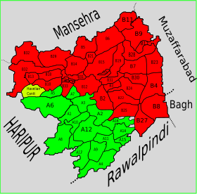
Havelian Tehsil
Appearance
Havelian Tehsil
تحصیل حویلیاں | |
|---|---|
 The valley of the Dor | |
 | |
| Country | |
| Province | Khyber Pakhtunkhwa |
| District | Abbottabad |
| Headquarters | Havelian |
| Government | |
| • Chairman | Uzair Sher Khan[1][2][3] (IND) |
| Population | |
| • Total | 351,322 |
| Time zone | UTC+5 (PST) |
| Number of towns | 1 |
| Number of Union Councils | 16 |
Havelian Tehsil is an administrative subdivision (tehsil) of Abbottabad District in the Khyber Pakhtunkhwa province of Pakistan.
History
[edit]During British rule, the current district of Abbottabad was created as a Tehsil of Hazara District.[5] After the independence of Pakistan it remained a tehsil of Hazara until 1981, when the old Abbottabad Tehsil became a district. Subsequently, the district was split into two tehsils, namely Abbottabad and Havelian.
Subdivisions
[edit]Municipal Committees
[edit]- Havelian (Headquarters)
Cantonments
[edit]Union Councils
[edit]- Nara
- Havelian
- Nagri Totial
References
[edit]- ^ "Independent Candidate Uzair Sher Khan Claims Havelian Tehsil Chairman By-poll". UrduPoint website. 7 August 2023.
- ^ "JUIF defeated in Mathra LG by-polls". The News International newspaper. 7 August 2023.
- ^ "Uzair Sher wins slot of Havelian tehsil chairman". 24 News TV channel website. 6 August 2023.
- ^ "DISTRICT AND TEHSIL LEVEL POPULATION BLOCKWISE WITH REGION BREAKUP: KHYBER PAKHTUNKHWA (see page 26 of 36 for Havelian Tehsil)" (PDF). Pakistan Bureau of Statistics, Government of Pakistan website. Archived from the original (PDF) on 5 September 2018. Retrieved 5 November 2023.
- ^ Abbottābād Tahsīl - Imperial Gazetteer of India, v. 5, p. 1
