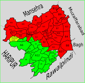
Abbottabad Tehsil
Appearance
Abbottabad Tehsil
تحصیل ایبٹ آباد | |
|---|---|
 | |
| Country | |
| Province | |
| District | Abbottabad |
| Headquarters | Abbottabad |
| Population | |
| • Tehsil | 981,590 |
| • Urban | 244,842 |
| • Rural | 736,748 |
| Time zone | UTC+5 (PST) |
| Number of towns | 1 |
| Number of Union Councils | 35 |
Abbottabad Tehsil (Urdu: تحصیل ایبٹ آباد) is an administrative subdivision (tehsil) of Abbottabad District in the Khyber Pakhtunkhwa province of Pakistan.
History
[edit]During the British rule, the current district of Abbottabad was created as a Tehsil of Hazara District.[2] After Pakistan′s independence from Britain on 14 August 1947, it remained a tehsil of Hazara until 1981 when the old Abbottabad Tehsil became a district, containing two tehsils - Abbottabad and Havelian.
Subdivisions
[edit]Municipal Committees
[edit]- Abbottabad (Headquarters)
Cantonments
[edit]Town Councils
[edit]Union Councils
[edit]- Bagan
- Bagh
- Bagnotar
- Bakot
- Bal Dheri
- Banda Qazi
- Bandi Dhundan
- Biran Gali
- Birot Kalan
- Birot Khurd
- Boi
- Chamhad
- Chatri
- Dahamtore
- Galiat
- Gojri Union Council
- Dalola
- Jarral
- Jhangi
- Kakol
- Kakot
- Kassaki Kalan
- Kokmang
- Kothiala
- Lakhala
- Malach
- Moolia
- Mir Pur
- Nagaki
- Nagri Bala
- Namal
- Namli Mera
- Nawan Shehr Janubi
- Nawan Shehr Shumali
- Palak
- Pattan Kalan
- Pawa
- Phal Kot
- Pind Kargoo Khan
- Qasba Abbatabad
- Rach Behn
- Rialah
- Salhad
- Seri Shehr Shah
- Sheikhul Bandi
- Sherwan
- Sir Bhanna
- Tar Nawai
References
[edit]- ^ "DISTRICT AND TEHSIL LEVEL POPULATION SUMMARY WITH REGION BREAKUP: KHYBER PAKHTUNKHWA" (PDF). Pakistan Bureau of Statistics. 2021-03-19. Archived (PDF) from the original on 2019-08-04. Retrieved 2018-04-17.
- ^ Abbottābād Tahsīl - Imperial Gazetteer of India, v. 5, p. 1
