Guntín
Appearance
Guntín | |
|---|---|
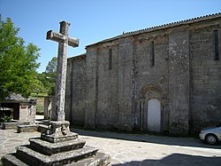
 Monastery of Santa María de Ferreira de Pallares. | |
 Location of Guntín. | |
| Country | |
| Autonomous community | |
| Province | Lugo |
| Comarca | Lugo |
| Government | |
| • Alcalde | Ángel Pérez Rodríguez (PPdeG) |
| Area | |
• Total | 154.78 km2 (59.76 sq mi) |
| Population | |
• Total | 2,551 |
| • Density | 16/km2 (43/sq mi) |
| Demonym(s) | Guntinés, pallarego |
| Time zone | UTC+1 (CET) |
| • Summer (DST) | UTC+2 (CEST) |
| Postal code | 27023 |
| Website | Official website |
Guntín (Galician pronunciation: [ɡunˈtiŋ]) is a municipality in the province of Lugo, in the autonomous community of Galicia, Spain. It belongs to the comarca of Lugo.
History
[edit]Guntín was the former capital of the former jurisdiction of Terra de Pallares.
References
[edit]- ^ "Ángel Pérez ya es el nuevo alcalde de Guntín y, con 27 años, es el más joven de la provincia". El Progreso de Lugo (in Spanish). 24 April 2024. Retrieved 27 August 2024.
- ^ "Ángel Pérez, 28 años, próximo alcalde de Guntín: «Se mo din hai unha semana, non o creo»". La Voz de Galicia (in Spanish). 15 April 2024. Retrieved 27 August 2024.
- ^ "Entidades Locales". ssweb.seap.minhap.es. Retrieved 27 August 2024.
- ^ "Instituto Nacional de Estadística. (Spanish Statistical Institute)". www.ine.es. Retrieved 27 August 2024.
External links
[edit]42°53′16″N 7°41′50″W / 42.8878°N 7.6972°W

