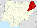
Gubio
Gubio | |
|---|---|
LGA and town | |
 | |
| Coordinates: 12°29′51″N 12°46′48″E / 12.49750°N 12.78000°E | |
| Country | |
| State | Borno State |
| Time zone | UTC+1 (WAT) |
 | |
Gubio, also Gobiyo, is a Local Government Area of Borno State, in northeastern Nigeria. Its headquarters are in the town of Gubio.
It has an area of 2,464 km2 and a population of 152,778 at the 2006 census.[citation needed]
The postal code of the area is 602.[1]
The primary road through Gubio runs north towards Damasak and south towards Maiduguri. Gubio is about 60 miles from each of those two settlements.
It is one of the sixteen LGAs that constitute the Borno Emirate, a traditional state located in Borno State, Nigeria.[2]
Massacre
[edit]On 9 June 2020, a group of gunmen killed 81 people in a massacre. The killers are believed to be from the jihadist group Boko Haram, whose insurgency began in 2009.[3]
Climate
[edit]The annual temperature in Gubio, Nigeria's Subtropical steppe region, is 31.59°C, 2.13% higher than the country's average, with 35.73mm of precipitation and 60.47 days with rain.[4][5]
Gubio's climate is becoming warmer due to climate change, with both warmer and colder weather.[6]
References
[edit]- ^ "Post Offices- with map of LGA". NIPOST. Archived from the original on 2009-10-07. Retrieved 2009-10-20.
- ^ Nigeria (2000). Nigeria: a people united, a future assured. Vol. 2, State Surveys (Millennium ed.). Abuja, Nigeria: Federal Ministry of Information. p. 106. ISBN 9780104089.
- ^ Dozens killed in attack in northern Nigeria
- ^ "Gubio, Borno, NG Climate Zone, Monthly Averages, Historical Weather Data". tcktcktck.org. Retrieved 2023-09-12.
- ^ "Gubio Climate, Weather By Month, Average Temperature (Nigeria) - Weather Spark". weatherspark.com. Retrieved 2023-09-12.
- ^ "Climate Change Gubio". meteoblue. Retrieved 2023-10-23.

