Askira/Uba
Askira/Uba | |
|---|---|
 | |
 | |
| Coordinates: 10°38′21″N 12°52′43″E / 10.63917°N 12.87861°E | |
| Country | |
| State | Borno State |
| Capital | Askira |
| Local Government Area | Askira/Uba was created 1976. |
| Government | |
| • Type | Democracy |
| • Executive Chairman | Abubakar Umar Mazhinyi (All Progressive Congress) |
| Time zone | UTC+1 (WAT) |
 | |
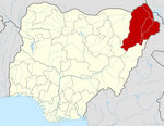
Askira/Uba is a Local Government Area of Borno State, Nigeria. Its headquarters are in the town of Askira.
It has an area of 2,362 km2 and a population of 138,091 at the 2006 census.
The postal code of the area is 601.[1]
One of the villages of Askira/Uba, Lassa, was the origin of a new virus found in the blood of returning American missionaries, and first identified by a virology research team in a laboratory at Yale University, who named it "Lassa virus" after the location where it first appeared.[2] Askira/Uba has two Emirate Councils namely; Askira Emirate and Uba Emirate.
Askira was founded by Muhammadu Mai Maina in 1921.[3]: 19
In July 2014, the villages of Huyim and Dille in Askira/Uba LGA were attacked by suspected Boko Haram gunmen, with nine and thirty-eight deaths respectively. The attackers came from the Sambisa Forest. Displaced residents "need help from governments and spirited individuals."[4][5]
Climate/Geography
[edit]The dry season in Askira is scorching and somewhat cloudy, whereas the wet season is hot, muggy, and cloudy. The average annual temperature fluctuates between 59°F and 103°F; it is rarely lower or higher than 54°F or 108°F. The hot season, which runs from March 8 to May 10, lasts for 2.0 months and with daily highs that average more than 99°F. In Askira, April is the warmest month of the year, with typical highs of 102°F and lows of 78°F.[6] The 2.8-month cool season, which runs from July 3 to September 28, has an average daily maximum temperature of less than 89°F. With an average low temperature of 60°F and high temperature of 89°F, January is the coldest month of the year in Askira.[7][8][6]
There are two distinct seasons in Askira Uba LGA, which has a total area of 2,362 square kilometers. The rainy season lasts longer than the other and is characterized by exceptionally hot temperatures. Large tracts of dry, arid land are found in the region, which has a semi-arid climate. In Askira Uba, the average temperature is 37 degrees Celsius, and the local humidity is 18%.[9][6][10]
Clouds
[edit]Over the course of the year, Askira's average percentage of cloud cover varies significantly based on the season. In Askira, the clearer season lasts about 4.4 months, starting around October 26 and ending around March 6. January is the clearest month of the year in Askira, with the sky being clear, mostly clear, or partly cloudy 58% of the time on average. The cloudier portion of the year lasts about 7.6 months, from around March 6 to October 26. In Askira, May is the cloudiest month of the year, with the sky being overcast or mostly cloudy 75% of the time on average.[11][6]
References
[edit]- ^ "Post Offices- with map of LGA". NIPOST. Archived from the original on 7 October 2009. Retrieved 2009-10-20.
- ^ Prono, Luca (9 January 2008). Zhang, Yawei (ed.). Encyclopedia of Global Health. Vol. 1. SAGE. ISBN 978-1-4129-4186-0. OCLC 775277696.
- ^ Kirk-Greene, A. H. M. (Anthony Hamilton Millard) (1971). West African travels and adventures; two autobiographical narratives from Northern Nigeria. Internet Archive. New Haven, Yale University Press. ISBN 978-0-300-01426-6.
- ^ "Nigeria: Gunmen Kill Nine in Borno Village". Retrieved 2014-07-18.
- ^ Hamza Idris; Yahaya Ibrahim (2014-07-15). "Nigeria: 38 Killed As Boko Haram Attacks Borno Village". Daily Trust - AllAfrica. Retrieved 2014-07-18.
- ^ a b c d "Askira Climate, Weather By Month, Average Temperature (Nigeria) - Weather Spark". weatherspark.com. Retrieved 2024-08-08.
- ^ "Nigeria-Borno: Askira/Uba Local Government Area (LGA) (as of 05 February 2018) | OCHA". www.unocha.org. 2018-02-27. Retrieved 2024-08-08.
- ^ "Askira, Nigeria Hourly Weather Forecast | Weather Underground". www.wunderground.com. Retrieved 2024-08-08.
- ^ "Askira / Uba Local Government Area". www.manpower.com.ng. Retrieved 2024-08-08.
- ^ "Weather in Askira-Uba district". meteocast.net. Retrieved 2024-08-08.
- ^ "10-day weather forecast for Askira, Borno, Nigeria - The Weather Channel | weather.com". The Weather Channel. Retrieved 2024-08-08.

