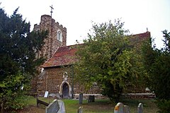
Gravenhurst, Bedfordshire
Appearance
| Gravenhurst | |
|---|---|
 St Mary's church | |
Location within Bedfordshire | |
| Population | 595 (2011 Census)[1] |
| OS grid reference | TL121143 |
| Unitary authority | |
| Ceremonial county | |
| Region | |
| Country | England |
| Sovereign state | United Kingdom |
| Post town | BEDFORD |
| Postcode district | MK45 |
| Dialling code | 01462 |
| Police | Bedfordshire |
| Fire | Bedfordshire and Luton |
| Ambulance | East of England |
| UK Parliament | |
Gravenhurst is a civil parish located in the Central Bedfordshire district of Bedfordshire, England.
The parish includes Lower Gravenhurst, Upper Gravenhurst, as well as the hamlet of Ion.[2]
Features of Gravenhurst include St. Mary's Church, which was built during the 14th century.[3]
History
[edit]Gravenhurst was recorded in the Domesday Book as Crauenhest.[4] The entry reads: Crauenhest: William from Hugh de Beauchamp. The parish was formed on 24 March 1888 from "Lower Gravenhurst" and "Upper Gravenhurst".[5]
References
[edit]- ^ "Civil Parish population 2011". Neighbourhood Statistics. Office for National Statistics. Retrieved 8 November 2016.
- ^ "'Guide to Bedfordshire Parishes'". Bedfordshire.gov.uk. Archived from the original on 13 February 2012. Retrieved 6 August 2012.
- ^ "'Gravenhurst history timeline'". Galaxy.bedfordshire.gov.uk. 15 March 2007. Archived from the original on 22 February 2012. Retrieved 6 August 2012.
- ^ "Bedfordshire A-H". The Domesday Book Online. Retrieved 31 January 2023.
- ^ "Ampthill Registration District". UKBMD. Retrieved 31 January 2023.
External links
[edit]![]() Media related to Gravenhurst, Bedfordshire at Wikimedia Commons
Media related to Gravenhurst, Bedfordshire at Wikimedia Commons

