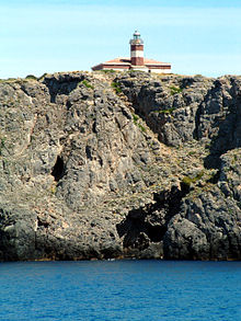
Giannutri Lighthouse
Appearance
 Giannutri Lighthouse | |
 | |
| Location | Giannutri Tuscany Italy |
|---|---|
| Coordinates | 42°14′22″N 11°06′29″E / 42.239371°N 11.108077°E |
| Tower | |
| Constructed | 1882 |
| Foundation | concrete base |
| Construction | masonry tower |
| Automated | yes |
| Height | 9 metres (30 ft) |
| Shape | cylindrical tower with balcony and lantern attached to the front side of one-storey keeper's house |
| Markings | tower and building painted in red and white stripes, grey metallic lantern dome |
| Power source | solar power |
| Operator | Marina Militare[1][2] |
| Fog signal | no |
| Light | |
| Focal height | 61 metres (200 ft) |
| Lens | Type OF |
| Intensity | LABI 100 w |
| Range | main: 13 nautical miles (24 km; 15 mi) |
| Characteristic | Fl W 5s. |
| Italy no. | 2184 E.F |
Giannutri Lighthouse (Italian: Faro di Giannutri) is an active lighthouse, located at Punta Rossa, the southernmost part of the island and of the Tuscan Archipelago on the Tyrrhenian Sea.
Description
[edit]The lighthouse, built in 1882, consists of a masonry cylindrical tower, 9 metres (30 ft) high attached to the front side of a one-storey keeper's house, painted with red and white horizontal bands.
The light is positioned at 61 metres (200 ft) above sea level and emits one white flash in a 5 seconds period, visible up to a distance of 13 nautical miles (24 km; 15 mi). The lighthouse is completely automated, powered by a solar unit, and managed by the Marina Militare with the identification code number 2184 E.F.[2]
See also
[edit]References
[edit]- ^ Rowlett, Russ. "Lighthouses of Italy: Tuscany". The Lighthouse Directory. University of North Carolina at Chapel Hill. Retrieved August 19, 2018.
- ^ a b "Isola di Giannutri". Marina Militare. Retrieved August 19, 2018.
External links
[edit]Wikimedia Commons has media related to Giannutri lighthouse.
