Gallatin Gateway, Montana
Gallatin Gateway, Montana | |
|---|---|
| Coordinates: 45°35′29″N 111°11′51″W / 45.59139°N 111.19750°W | |
| Country | United States |
| State | Montana |
| County | Gallatin |
| Area | |
| • Total | 5.95 sq mi (15.40 km2) |
| • Land | 5.85 sq mi (15.15 km2) |
| • Water | 0.10 sq mi (0.25 km2) |
| Elevation | 4,974 ft (1,516 m) |
| Population (2020) | |
| • Total | 967 |
| • Density | 165.33/sq mi (63.84/km2) |
| Time zone | UTC-7 (Mountain (MST)) |
| • Summer (DST) | UTC-6 (MDT) |
| ZIP code | 59730 |
| Area code | 406 |
| FIPS code | 30-29875 |
| GNIS feature ID | 2583809[2] |
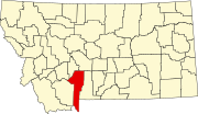
Gallatin Gateway is a census-designated place (CDP) in Gallatin County, Montana, United States. As of the 2010 census it had a population of 856.[3] Elevation is 4,953 ft (1,510 m).
The community is located along U.S. Route 191 in the valley of the Gallatin River, a north-flowing tributary of the Missouri River. US 191 leads north, then east 13 miles (21 km) to Bozeman and south 28 miles (45 km) to Big Sky. According to the U.S. Census Bureau, the CDP has a total area of 5.9 square miles (15.4 km2), of which 5.8 square miles (15.1 km2) is land and 0.1 square miles (0.3 km2), or 1.83%, is water.[3]
Demographics
[edit]| Census | Pop. | Note | %± |
|---|---|---|---|
| 2020 | 967 | — | |
| U.S. Decennial Census[4] | |||
History
[edit]Salesville was one of the pioneer towns, named for Z. Sales, who secured a saw mill started by J. J. Tomlinson, continuing the business on the West Gallatin river several years. With his family, he established the town on his property, the name of the town being changed in 1927 to Gallatin Gateway,[5] by The Milwaukee Road, when the town became the terminus of the branch line from Three Forks, carrying passengers for the trip through Yellowstone National Park by way of Gallatin Canyon.
The passenger depot that was built at that time was established in the commodious Gallatin Gateway Inn built by the railroad. A good brick school house, some substantial business blocks and comfortable homes are found there.[6] Opening June 17, 1927, The Gallatin Gateway Inn was touted as one of the most luxurious and beautiful hotels of the day. In 1980 the Inn received Historic Landmark designation after an extensive restoration effort (the Milwaukee Road left the Northwestern U.S. that year).
Education
[edit]Most of it is in Gallatin Gateway Elementary School District while a part of it is in Bozeman Elementary School District. All of it is in Bozeman High School District.[7] The Bozeman elementary and high school districts are both a part of Bozeman Public Schools.[8]
References
[edit]- ^ "ArcGIS REST Services Directory". United States Census Bureau. Retrieved September 5, 2022.
- ^ a b U.S. Geological Survey Geographic Names Information System: Gallatin Gateway, Montana
- ^ a b "Geographic Identifiers: 2010 Demographic Profile Data (G001): Gallatin Gateway CDP, Montana". American Factfinder. U.S. Census Bureau. Retrieved December 21, 2016.[dead link]
- ^ "Census of Population and Housing". Census.gov. Retrieved June 4, 2016.
- ^ "Gallatin Gateway". Montana Place Names Companion. Montana Historical Society. Retrieved April 2, 2021.
- ^ "Early History of Gallatin County, Montana".
- ^ "2020 CENSUS - SCHOOL DISTRICT REFERENCE MAP: Gallatin County, MT" (PDF). U.S. Census Bureau. p. 1 (PDF p. 2/3). Retrieved October 4, 2024. - Text list
- ^ "Directory of Montana Schools". Montana Office of Public Instruction. March 13, 2024. pp. 99-100/317. Retrieved March 13, 2024.


