East Springfield, Ohio
East Springfield, Ohio | |
|---|---|
 Travelling through East Springfield on Ohio State Route 43 | |
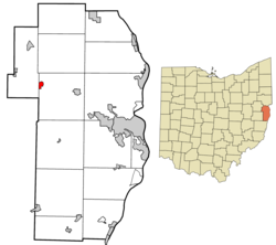
 Location of East Springfield in Jefferson County and in the state of Ohio | |
| Coordinates: 40°26′51″N 80°51′36″W / 40.44750°N 80.86000°W | |
| Country | United States |
| State | Ohio |
| County | Jefferson |
| Township | Salem |
| Area | |
• Total | 0.41 sq mi (1.06 km2) |
| • Land | 0.41 sq mi (1.06 km2) |
| • Water | 0.00 sq mi (0.00 km2) |
| Elevation | 1,240 ft (380 m) |
| Population (2020) | |
• Total | 185 |
| • Density | 451.22/sq mi (174.05/km2) |
| Time zone | UTC-5 (Eastern (EST)) |
| • Summer (DST) | UTC-4 (EDT) |
| ZIP code | 43925 |
| Area code | 740 |
| FIPS code | 39-24066 |
| GNIS Feature ID | 2628890[2] |
East Springfield is a census-designated place (CDP) in northwestern Salem Township, Jefferson County, Ohio, United States. It has a post office with the ZIP code 43925.[3] It lies along State Route 43, 16 miles (26 km) northwest of the county seat of Steubenville and 17 miles (27 km) southeast of Carrollton. The community is part of the Weirton–Steubenville, WV-OH Metropolitan Statistical Area.
History
[edit]East Springfield was laid out in 1803.[4] A post office called East Springfield has been in operation since 1849.[5]
Demographics
[edit]| Census | Pop. | Note | %± |
|---|---|---|---|
| 2020 | 185 | — | |
| U.S. Decennial Census[6] | |||
Education
[edit]East Springfield is part of the Edison Local School District. Campuses serving the community include the John Gregg Elementary School (Preschool-Grade 4), Springfield Middle School (Grades 5-8), and Edison High School (Grades 9-12).
References
[edit]- ^ "ArcGIS REST Services Directory". United States Census Bureau. Retrieved September 20, 2022.
- ^ a b U.S. Geological Survey Geographic Names Information System: East Springfield, Ohio
- ^ USPS – Cities by ZIP Code
- ^ Doyle, Joseph Beatty (1910). 20th Century History of Steubenville and Jefferson County, Ohio and Representative Citizens. Richmond-Arnold Publishing Company. pp. 519.
- ^ "Jefferson County". Jim Forte Postal History. Archived from the original on January 29, 2016. Retrieved January 2, 2016.
- ^ "Census of Population and Housing". Census.gov. Retrieved June 4, 2016.


