Draft:Firth of Clyde Marine Protected Area
Submission declined on 27 August 2024 by CFA (talk).
Where to get help
How to improve a draft
You can also browse Wikipedia:Featured articles and Wikipedia:Good articles to find examples of Wikipedia's best writing on topics similar to your proposed article. Improving your odds of a speedy review To improve your odds of a faster review, tag your draft with relevant WikiProject tags using the button below. This will let reviewers know a new draft has been submitted in their area of interest. For instance, if you wrote about a female astronomer, you would want to add the Biography, Astronomy, and Women scientists tags. Editor resources
|  |
| Firth of Clyde Marine Protected Area | |
|---|---|
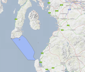
 Location and extent of the Clyde Sill MPA in the Firth of Clyde | |
| Location | Firth of Clyde, Scotland |
| Area | 712 km2 (275 sq mi) |
| Designation | Scottish Government |
| Established | 7 August 2014 |
| Operator | Marine Scotland |
Firth of Clyde Marine Protected Area or Clyde Sea Sill (MPA(NC) is a Marine Protected Area in Scotland and is managed by Marine Scotland it was created on 7 August 2014. The NatureScot Site Code is 10414, the EU Site Code is 555560461.
The area covered is on the boundary between the Firth of Clyde and the Irish Sea in the North Channel (Great Britain and Ireland).[1][2][3][4][5][6]
As of March 2022, there are thirty six Marine Protected Areas in Scotland, of which the Clyde Sea Sill is one.[7]
References
[edit]- ^ "Clyde Sea Sill MPA".
- ^ "SiteLink". sitelink.nature.scot.
- ^ "Marine Protected Areas (MPAs) | NatureScot".
- ^ "Marine Protected Area (MPA) network | marine.gov.scot". marine.gov.scot.
- ^ "Marine Protected Areas (MPAs)". www.gov.scot.
- ^ "Clyde SMR | Scotland's Marine Assessment 2020". marine.gov.scot.
- ^ https://marine.gov.scot/data/facts-and-figures-about-scotlands-sea-area-coastline-length-sea-area-sq-kms

- in-depth (not just passing mentions about the subject)
- reliable
- secondary
- independent of the subject
Make sure you add references that meet these criteria before resubmitting. Learn about mistakes to avoid when addressing this issue. If no additional references exist, the subject is not suitable for Wikipedia.