Csikóstőttős
Appearance
This article needs additional citations for verification. (April 2020) |
Csikóstőttős | |
|---|---|
 | |
| Coordinates: 46°20′23″N 18°09′17″E / 46.339769°N 18.154711°E | |
| Country | Hungary |
| Region | Southern Transdanubia |
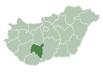
| County | Tolna |
| Subregion | Dombovári |
| Rank | Village |
| Area | |
• Total | 20.44 km2 (7.89 sq mi) |
| Time zone | UTC+1 (CET) |
| • Summer (DST) | UTC+2 (CEST) |
| Postal code | 7341 |
| Area code | +36 74 |
| Website | https://csikostottos.hu/ |
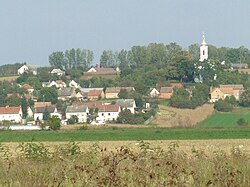
Csikóstőttős is a village in Tolna County, Hungary.
46°20′N 18°9′E / 46.333°N 18.150°E
References
[edit]- ^ a b Csikóstőttős at the Hungarian Central Statistical Office (Hungarian).


