Collinsburg, Pennsylvania
Appearance
Collinsburg, Pennsylvania | |
|---|---|
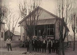
 The first store built in Collinsburg, in the early 20th century | |
 | |
| Country | United States |
| State | Pennsylvania |
| County | Westmoreland |
| Area | |
• Total | 1.80 sq mi (4.66 km2) |
| • Land | 1.78 sq mi (4.60 km2) |
| • Water | 0.02 sq mi (0.06 km2) |
| Population | |
• Total | 1,048 |
| • Density | 589.76/sq mi (227.74/km2) |
| Time zone | UTC-5 (Eastern (EST)) |
| • Summer (DST) | UTC-4 (EDT) |
| FIPS code | 42-15248 |
Collinsburg is a census-designated place[3] located in Rostraver Township, Westmoreland County in the state of Pennsylvania, United States. As of the 2010 census[4] the population was 1,125 residents.


Demographics
[edit]| Census | Pop. | Note | %± |
|---|---|---|---|
| 2020 | 1,048 | — | |
| U.S. Decennial Census[5][2] | |||
References
[edit]- ^ "ArcGIS REST Services Directory". United States Census Bureau. Retrieved October 12, 2022.
- ^ a b "Census Population API". United States Census Bureau. Retrieved October 12, 2022.
- ^ https://www.census.gov/2010census/popmap/ipmtext.php?fl=42:4215248 [dead link]
- ^ https://www.census.gov/# [not specific enough to verify]
- ^ "Census of Population and Housing". Census.gov. Retrieved June 4, 2016.


