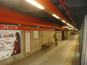
Cinecittà (Rome Metro)
Appearance
This article relies largely or entirely on a single source. (April 2017) |
 | |||||||||||
| General information | |||||||||||
| Coordinates | 41°50′55″N 12°34′31″E / 41.8487°N 12.5754°E | ||||||||||
| Owned by | ATAC | ||||||||||
| Platforms | Side platform | ||||||||||
| Tracks | 2 | ||||||||||
| Construction | |||||||||||
| Structure type | Underground | ||||||||||
| History | |||||||||||
| Opened | 1980 | ||||||||||
| Services | |||||||||||
| |||||||||||
| |||||||||||
Cinecittà is a station on the Rome Metro. It is on Line A and is located at the intersection of Via Tuscolana, Via di Torre Spaccata and Via delle Capannelle.[1]
References
[edit]- ^ "Rome.info > Rome metro map". rome.info. Retrieved 2014-04-18.


