Carminow Cross
Appearance
| Carminow Cross | |
|---|---|
 | |
| Location | Bodmin, Cornwall, England |
| Coordinates | 50°27′35″N 4°41′40″W / 50.459803°N 4.69457°W |
| Official name | Carminow Cross |
| Designated | 22 March 1932 |
| Reference no. | 1008177 |
Listed Building – Grade II* | |
| Official name | Stone Cross at SX 088 656, Carminow |
| Designated | 26 March 1949 |
| Reference no. | 1298242 |
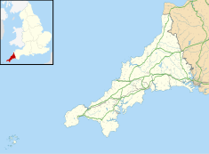
Carminow Cross is a stone Celtic cross near a major road junction southeast of Bodmin in mid-Cornwall, England. Immediately to the north is Castle Canyke, an Iron Age fort.[1] The cross is a Grade II* listed building.[2]
In the late 19th century and early 20th century the cross was half hidden in a hedge at the back of some cottages which then formed the hamlet of Carminow Cross. A. G. Langdon conjectured that its original position was at the crossroads, before it was moved into the hedge.[3] When road widening was undertaken in the mid-20th century it was moved to its present position surrounded by grass verge.
References
[edit]- ^ Ordnance Survey One-inch Map of Great Britain; Bodmin and Launceston, sheet 186. 1961
- ^ Historic England. "Stone Cross at SX 088 656, Carminow (Grade II*) (1298242)". National Heritage List for England. Retrieved 24 October 2015.
- ^ Langdon, Arthur G. (1896). Old Cornish Crosses. Truro: J. Pollard. pp. 311-13.
External links
[edit]Wikimedia Commons has media related to Carminow Cross.
- Castle Canyke; themodernantiquarian.com
50°27′35″N 4°41′40″W / 50.459803°N 4.69457°W

