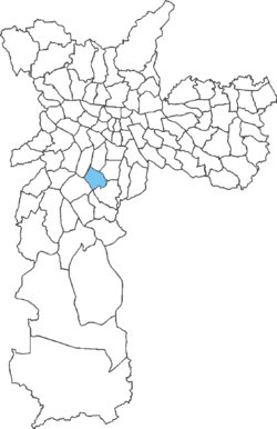
Campo Belo (district of São Paulo)
Appearance
23°37′18″S 46°40′19″W / 23.6217°S 46.6719°W
Campo Belo | |
|---|---|
 District of the city of São Paulo | |
 | |
| Country | |
| State | |
| Municipality | |
| Subprefecture | Santo Amaro |
| Area | |
| • Total | 8.80 km2 (3.40 sq mi) |
| Population (2007) | |
| • Total | 65,752 |
| • Density | 4,472/km2 (11,580/sq mi) |
| Website | Subprefecture of Santo Amaro |
Campo Belo is one of 96 districts in the city of São Paulo, Brazil.[1]
Campo Belo is a district located in the southern region of the municipality of São Paulo, on the northern border of the former municipality of Santo Amaro. In recent years, it has become an area of large middle and upper-middle class buildings.[2]
See also
[edit]References
[edit]- ^ "Dados Demográficos dos Distritos pertencentes as Subprefeituras". prefeitura.sp.gov.br (in Portuguese). City of São Paulo. Archived from the original on 2012-09-21. Retrieved 28 December 2014.
- ^ "EncontraCampoBelo.com | Guia de Campo Belo » EncontraCampoBelo.com". EncontraCampoBelo.com (in Brazilian Portuguese). Retrieved 2024-08-27.
External links
[edit]

