Botuporã
Appearance
From Wikipedia, the free encyclopedia
This article needs additional citations for verification. Please help improve this article by adding citations to reliable sources. Unsourced material may be challenged and removed. Find sources: "Botuporã" – news · newspapers · books · scholar · JSTOR (August 2013) (Learn how and when to remove this message) |
Place in Bahia, Nordeste
Botuporã | |
|---|---|
 | |
| Coordinates: 13°22′55″S 42°31′22″W / 13.38194°S 42.52278°W / -13.38194; -42.52278 | |
| Region | Nordeste |
| State | Bahia |
| Population (2020 [1]) | |
| • Total | 10,129 |
| Time zone | UTC−3 (BRT) |
| Postal code | 2904209 |
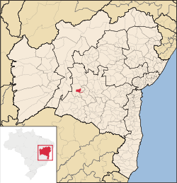
Botuporã is a municipality in the state of Bahia in the North-East region of Brazil.
See also
[edit]References
[edit]Retrieved from "https://en.wikipedia.org/w/index.php?title=Botuporã&oldid=1241408636"


