Banamba
Banamba | |
|---|---|
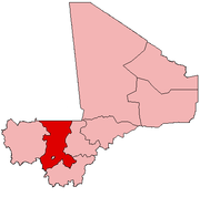
Location within Mali | |
| Coordinates: 13°33′0″N 7°27′0″W / 13.55000°N 7.45000°W | |
| Country | |
| Region | Koulikoro Region |
| Cercle | Banamba Cercle |
| Elevation | 372 m (1,223 ft) |
| Time zone | UTC+0 (GMT) |
Banamba is the capital of Banamba Cercle, one of the seven Cercles of the Koulikoro Region of Mali. Its estimated 2008 population is 7000. The town lies due north of the regional capital of Koulikoro, and is connected by a 40 km all-weather road via the town of Sirakorola, about halfway between the two. It is the location of the Lycée Franco-Arabe de Banamba.
Physical layout
[edit]It takes about twenty minutes to walk from one end to the other. There are old neighborhoods with narrow, winding alleys, and newer neighborhoods (particularly the NE) with a grid of wider streets. The market, the great mosque, the pharmacy, the post office, the Cercle building, the library, and the schools are all close together. Roads approach the town from all directions; the roads from Koulikoro (to the South) and from Kiban (to the East) are laterite. A line of ponds, dry before the rainy season, lies to the West of the market.
History
[edit]Banamba was founded by Marka people from Sokolo in the 1840s, but remained a small, unimportant village in the insecure frontier region between the Bamana Empire and Kaarta up until the 1860s.[1]: 171 [2]: 378 The Toucouleur Empire's conquest of the middle Niger river valley both destabilized the traditional riverine trade routes and opened up a new east-west axis linking Segou with Nioro du Sahel. Banamba was a key center on this new route, and became one of the most important trade towns in the region by the late 1870s.[3]: 417 By the 1890s, it was the primary entrepot for the slave trade towards the upper Senegal river valley, as well as an important agricultural center.[2]: 379
In July 1904 the Dakar-Niger railway reached Bamako. Improved access to foreign markets pushed Marka plantation owners around Banamba to intensify grain production by overworking their slaves. In March 1905 slaves began to leave their masters in droves, often returning to homes in the Sikasso and Bougouni cercles. Masters responded by holding slave women and children hostage in Banamba itself. The French governor Fawtier negotiated a compromise, but it only held until the next year. By that time, the colonial government had formally outlawed slavery, and defended the slaves' right to leave. The exodus begun in Banamba spread throughout the region, with hundreds of thousands of slaves leaving their masters.[2]: 388–93
Ethnic groups, customs
[edit]
The main ethnic groups found in Banamba are the Bambara, the Soninke, and the Fulani. The original settlers, whose family names are Simpara and Makaji, are related to the Soninke. Everyone speaks Bambara except some of the bush people, particularly Fulani, who come in to market on Mondays, though other languages can be heard, including Moor.
On holidays (Muhammad's birthday and baptism, Ramadan, Tabaski) women dance to drums in various little corners around town. Sometimes on moonlit nights children dance to xylophone.
Banamba has a day reserved for weddings in June each year, and on that day dozens of marriages take place.
A day in March or April is marked for seining the fish out of the ponds. Until that day the fish are untouched. Then dozens of men and boys wade in with their homemade nets.
Social life, sports
[edit]There are several soccer teams that play regularly. People play basketball and volleyball and ping pong at the lycée. Day to day social life consists mainly of walks around town chatting with passersby or making tea with family and friends. There are movies every night, including an occasional drama amid the karate spectacles. Dances are held at the school as often as once a month.
Surrounding area
[edit]Touba is within cycling distance. It is the home of a famous (so say the locals) Arabic school and a beautiful mosque on a hill. The town is divided by two Muslim sects (one of the Wahhabite) who do not get along well enough to share water.
Kiban is also nearby and sports a pretty little mosque.
Sirakola (Koulikoro Cercle) has a large market on Thursdays, on which days there is plenty of public transportation.
There is a big hill to the West, visible from town, and a couple smaller ones about five kilometers to the North on the road to Nara. The hills to the North are piles of bare boulders, hosts to hardy baobabs, good for watching sunsets.
Administrative structure
[edit]Banamba town is the administrative center of Banamba Cercle, which contains nine Communes, including Banamba. The Commune of Banamba contains not only the town itself, but is the administrative center for the following urban Quarters and rural villages:[4]
- Badoucourebougou
- Bakaribougou
- Bamarobougou
- Banamba
- Bougounina
- Dankolo
- Diangalambougou
- Diassani
- Diatouroubougou
- Fadabougou
- Falembougou
- Galo
- Galo-Marka
- Gana
- Kassela
- Kolondialan
- Kouna
- Madina
- N'galamadiby
- N'ganou
- N'ganouba
- Ouleny-Marka
- Ouleny-Peulh
- Sabalibougou
- Sinzena
- Tiontala
- Tomba
- Zambougou
References
[edit]- ^ Roberts, Richard (1980). "Long distance trade and production: Sinsani in the nineteenth century". Journal of African History. 21 (2): 169–188. doi:10.1017/S0021853700018156. Retrieved 25 October 2023.
- ^ a b c Roberts, Richard, and Martin A. Klein. “The Banamba Slave Exodus of 1905 and the Decline of Slavery in the Western Sudan.” The Journal of African History, vol. 21, no. 3, 1980, pp. 375–94. JSTOR, http://www.jstor.org/stable/181190. Accessed 23 Dec. 2023.
- ^ Roberts, Richard (1980). "Production and Reproduction of Warrior States: Segu Bambara and Segu Tokolor, c. 1712-1890". Journal of African History. 13 (3): 389–414. Retrieved 25 October 2023.
- ^ La Délégation Générale aux Elections: Mali. REGION DE KOULIKORO - CERCLE DE BANAMBA[permanent dead link].
- Banamba, Mali Page, Falling Rain .com.


