Ballinacourty
Appearance
This article includes a list of general references, but it lacks sufficient corresponding inline citations. (January 2021) |
Ballinacourty
Baile na Cúirte | |
|---|---|
Townland | |
 Ballinacourty lighthouse | |
 | |
| Country | Ireland |
| Province | Munster |
| County | Waterford |
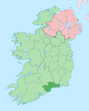
Ballinacourty, officially Ballynacourty (Irish: Baile na Cúirte, meaning 'town of the court or Courtown'),[1] is a rural area and townland on the southern coast of Ireland near Dungarvan, County Waterford.
Transport
[edit]A magnesite factory in the area was served by the last remaining part of the Waterford-Mallow railway line until the late 1980s.
Ballinacourty lighthouse, which stands at the entrance to Dungarvan Harbour, was built in 1858.
Sport
[edit]The local Gaelic Athletic Association club is Abbeyside/Ballinacourty GAA. The club plays both hurling and gaelic football and competes in both senior codes in the county.
References
[edit]- ^ "Placenames Database of Ireland". Archived from the original on 12 June 2012. Retrieved 16 September 2010.

