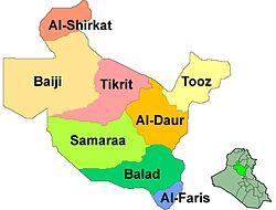
Balad District, Iraq
Appearance
Balad District | |
|---|---|
 | |
 | |
| Coordinates: 33°50′N 44°02′E / 33.833°N 44.033°E | |
| Country | |
| Governorate | Salah ad Din |
| Seat | Balad |
| Area | |
• Total | 2,469 km2 (953 sq mi) |
| Population (2003) | |
• Total | 167,590 |
| • Density | 68/km2 (180/sq mi) |
| Time zone | UTC+3 (AST) |
Balad District (Arabic: قضاء بلد) is a district of the Saladin Governorate, Iraq. It covers an area of 2,469 km2 (953 sq mi), and had a population of 167,590 in 2003. The district capital is the city of Balad.
Balad District
[edit]Balad District consists of several towns:
- Balad
- Al Dhuluiya
- Al Ishaqi
- Yathrib
- Aziz Balad
- Al Rowashid
- Tel Al Thahab
- Al Owaisat

