Baabda District
Baabda District | |
|---|---|
District | |
| بعبدا | |
 Baabda District | |
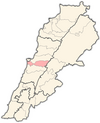
 Location in Lebanon | |
| Country | |
| Governorate | Mount Lebanon Governorate |
| Capital | Baabda |
| Area | |
• Total | 75 sq mi (194 km2) |
| Population | |
• Estimate (31 December 2017) | 568,714 |
| Time zone | UTC+2 (EET) |
| • Summer (DST) | UTC+3 (EEST) |
Baabda District (Arabic: قضاء بعبدا, transliteration: Qada' Baabda), sometimes spelled B'abda, is a district (qadaa) of Mount Lebanon Governorate, Lebanon, to the south and east of the Lebanon's capital Beirut. The region is also popularly known as "Southern Matn District" (المتن الجنوبي, transliteration: al-Matn al-Janoubi), as distinct from Northern Matn District, (المتن الشمالي; transliteration: al-Matn ash-Shimali). The capital of Baabda District is the city of Baabda.

Demographics
[edit]The inhabitants of the Baabda district are mainly Maronite Catholics, Shi'a Muslims and Druze. As of 2022, the religious make-up of the District's 171,746 voters were roughly 33% Maronite Catholics, 25% Shia, 17% Druze, 8% Greek Orthodox, 7% Sunni, and 10% others. [1]Shi'a Muslims in the Baabda district mostly inhabit the coastal area of the district which lies directly south of Beirut. This area is also known as Dahieh or the southern suburbs of Beirut. The Druze on the other hand, live in the mountainous area further inland.
As of the elections, six seats in the Lebanese Parliament are allocated to Baabda. Three of these seats are allocated to Maronite Catholics, two to the Shi'a Muslims and one to the Druze.[citation needed]
Environment and archaeology
[edit]Baabda District is the source of amber sites dating from 120 million years ago that have uncovered among the oldest lizards including the Baabdasaurus, and also many insects.
Cities and towns
[edit]- Abadieh
- Ain el Remmaneh
- Araya
- Arbiniyeh
- Baabda
- Baalchmay
- Betchay
- Bmariam
- Btekhnay
- Bourj el-Barajneh
- Chebanieh
- Chiyah
- Deir el Haref
- Falougha
- Jouar el-Haouz
- Furn el Chebbak
- Ghobeiry
- Hadath
- Hammana
- Haret Hreik
- Haret el Sitt
- Hazmieh
- Hlaliyeh
- Jamhour
- Kfarshima
- Kfar Selouane
- Khraybeh
- Knaisseh
- Kortada
- Krayyeh
- Ksaibe
- Laylakeh
- Qalaa
- Qarnayel
- Ras el-Matn
- Sebnay
- Tarchich
- Tohwita
- Wadi Chahrour
- Yarze
- Qoubbei

